| Atlas Florae Europaeae (AFE) maps the European
distribution of species and subspecies of vascular
plants. The distribution data gathered by the national
representatives of the Committee for Mapping the
Flora of Europe is edited by the Secretariat of the Committee
for Mapping the Flora of Europe in the Botanical
Museum of the Finnish Museum of Natural History in
Helsinki. In 1972 - 1999 twelve
volumes of the Atlas have been published by the Committee
for Mapping the Flora of Europe and Societas
Biologica Fennica Vanamo, with altogether 2039 pages
and 3270 maps. These were edited by Jaakko Jalas (volumes
1 - 12) and Juha Suominen (vol. 1 - 12), Raino Lampinen
(vol. 11 and 12), and Arto Kurtto (vol. 12). Since vol.
13 the Atlas is edited by Arto Kurtto (Editor-in-Chief of
Atlas Florae Europaeae) and Leo Junikka
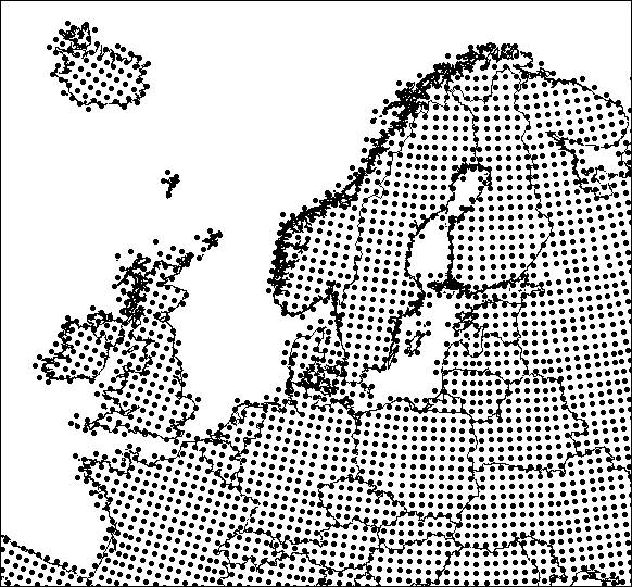
(Secretary of the mapping committee). The ranges have been mapped with the aid of a grid of c. 50 x 50 km squares, based on the Universal Transverse Mercator (UTM) projection and the Military Grid Reference System (MGRS). In volumes 1 - 12 there were somewhat above 4400 squares for the whole of Europe. After that the mapping grid has been changed and has now over 4700 grid cells across Europe. The notes on the maps give important synonyms, data on taxonomy and nomenclature, important additions and corrections (often complementing Flora Europaea) and references to maps of the total range. The most recent literature available has been consulted. The area mapped is that of Flora Europaea, but the mapping territories used in Atlas Florae Europaeae of somewhat different from those in Flora Europaea. The Azores and Spitsbergen appear as insets in the printed maps. The mapping symbols are different for native occurrences, introductions (established aliens), unknown or uncertain status, extinct, probably extinct and uncertain records. Within the same square, native occurrences are given preference over introductions, extant over extinct, certain over uncertain. The distribution maps published in AFE volumes 1 - 11 were made manually. Later the maps have been scanned and the distribution data has been extracted from them with custom software into a digital database. The contents of the AFE database can be viewed with a free Windows program. |
RL 24.10.2000