ATLAS
FLORAE EUROPAEAE
Atlas Florae Europaeae Database
During the first thirty years of Atlas Florae Europaeae (AFE),
the basic technology for the collection of distribution data and
publication of distribution maps has remained practically
unchanged. Manual map production as such is rather tedious.
Furthermore, distribution data available only on printed maps are
not suitable for further (computerized) analyses. The
construction of the Atlas Florae Europaeae database was
started in 1992. The primary goal was to make the distribution
data available in digital format, and the additional goal was the
computerization of the editorial process of AFE. The printed AFE
distribution maps were processed this way:
- the maps were scanned at 300 dpi resolution
- locations of the grid cells (4419) were calculated on the
scanned bitmap images
- arrays of black pixels were searched from the bitmaps
using custom software
- the map originals and and their interpretation were
compared using custom software
So far all printed AFE volumes (1 to 12) have been processed
this way.
ATLAS FLORAE EUROPAEAE 1999 - free software for map viewing
Plant distribution data in this product are based on the
printed volumes 1 to 11 of Atlas Florae Europaeae (1972-1996),
edited by Jaakko Jalas and Juha Suominen, together with Raino
Lampinen (Vol. 11). At present the maps cover about 20% of the
European vascular flora (pteridophytes to crucifers).
Please notice the following details when viewing the digital
distribution maps:
- UTM dot locations outside the AFE base map have sometimes
been used on the printed maps. These dots are missing
here.
- All taxa with ambiguous taxonomic status, mentioned in
quotation marks on the printed maps, have been omitted.
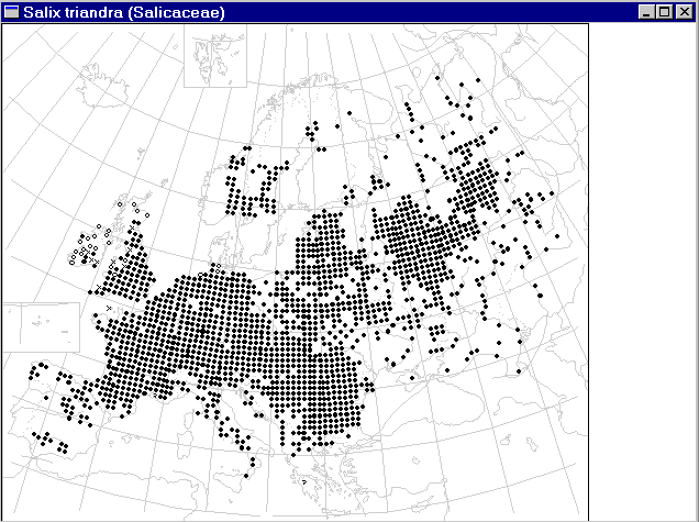
- AFE uses six symbol categories.
Note that in maps which combine several taxa at lower
ranks, the symbol priority is 1) native, present, 2)
unknown whether native and present, or a present
established alien, 3) established alien, present, 4)
possibly extinct (origin, ie. native, established or
unknown not shown), 5) extinct (without indication of
origin), 6) uncertain identification or locality.
- An explanation of the AFE grid system
(used up to vol. 12) and the Universal
Transverse Mercator (UTM) and the Military Grid Reference
System (MGRS) are given on the AFE web pages.
How to install and use the software (available
only for the 32-bit Windows95/Windows98/NT platforms):
- Download
the self-extracting afesetup.exe (704,275 bytes).
- Run afesetup.exe program. The archive will expand
and following files will be created: afe99.dot,
afe99.emf, afe99.exe, afe99.tax, readme.txt
- Create a desktop shortcut for starting afe99.exe, or
start the afe99.exe program from the Explorer.

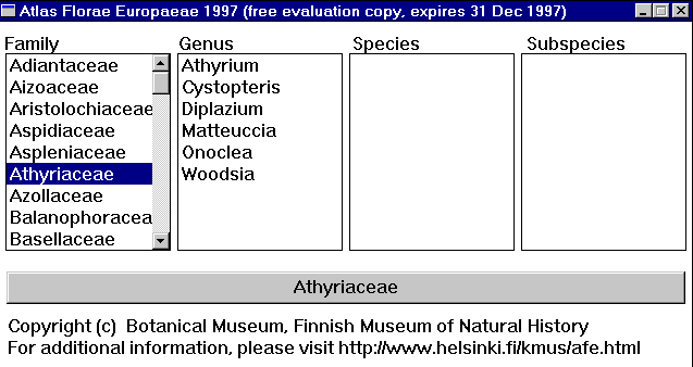
- Select the family, genus, species, or subspecies with the
left mouse button. The taxon name will be highlighted,
and appears in the grey bar near the bottom of the window
(as Athyriaceae in the image above).
- Click the grey bar to see the map. It is possibly to view
several maps simultaneously.

- You can make the map larger (or minimize or close it) by
using the buttons in the upper right corner of the map
window. Another way to enlarge or shrink the map window
is to place the mouse cursor above the border of the map
window, and then change the map window size by keeping
the left mouse button down and dragging the window
margin.
- You can zoom to a closer view by clicking the maps with
the mouse, and return into a more distant by clicking it
again.
- For moving the map windows, press the blue title using
the left mouse button, keep the button down, and move to
map window to a new place on the screen.
DISCLAIMER
There may still be errors in the distribution data shown on
the digital maps, due to difficulties in the interpretation of
certain scanned bitmaps. Please report all taxa with such
erroneous data to:
Leo Junikka (leo.junikka@helsinki.fi )
Botanical Museum
Finnish Museum of Natural History
P.O.Box 7 (Unioninkatu 44)
FIN-00014 HELSINKI UNIVERSITY
FINLAND


