The Atlas Florae Europaeae Data Editor is a program for creating text files that store the distribution of a certain taxon in Europe by editing the data files directly on a map. Alternatively the program can be used for viewing and editing distribution data files created elsewhere (e.g., extracted from a floristic database).
The distribution data files are stored in the program installation directory and have the ".afe" extension. These files are sent to the AFE Secretariat in Helsinki, where they will be incorporated into the main AFE database.
The program works under 32-bit Windows environment (Windows95, Windows98, Windows2000 and NT).
When the program is started, the map of Europe is drawn onto the screen, with red circles showing the grid cell locations. The circles can be hidden by removing the tick mark from the Show Grid item in the Options menu. Distribution data can be edited only when the grid cells are visible.
The size of the map window can be changed using the control buttons in the upper right corner of the program window, and by placing the mouse cursor over the border of the map window, pressing the left mouse button down and then by dragging the window border to the desired size.
A portion of the map can be zoomed by pressing the right mouse button down and then by dragging a rectangle onto the map. To view the whole map again, right click any location on the map.
To be able to edit distribution data, 1) the grid cell locations must be made visible by placing a tick mark to the Show Grid item in the Options menu and, 2) a taxon must have be selected using the New or Open command of the File menu. The name of the selected taxon is shown in the upper left corner of the window with bold text.
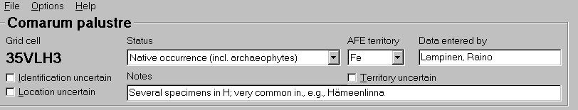
To make the data entry to a certain grid cell possible, the grid cell must be made active by selecting it with the left mouse button. The selected grid cell is then surrounded by a red square and its name (e.g., 35VLH3) is shown in the upper left corner of the window in bold text.
After a taxon has been selected, and the map has been made editable by activating the Show Grid item in the Options menu, and a grid cell has been selected for record entry, the following type of data can be entered in the uppermost part of the program window:
Status. The combo
box displays seven choices to select from. The first five ones
will be used in the AFE maps. The "recorded, status
undefined" value entries will not be mapped although, if
used, are stored in the distribution data files. The entries with
the "absent" value are, on the contrary, not saved. The
"absent" value can be used to remove a record from the
map.
The status combo box can be activated by selecting it with the
mouse or the tabulator. Once the combo box is active, the values
of status can be chosen by mouse, by writing the first character
of the status description, or by the arrow keys.
After a certain status has been selected, the corresponding map
symbol is drawn onto the map as shown in the image below.
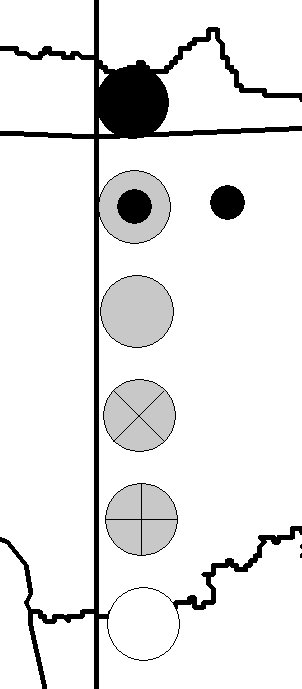 |
MAP SYMBOL EXPLANATIONS: black dot = native occurrence (incl. archaeophytes) grey dot with a small black dot = status unknown or uncertain grey dot = introduced (established alien) grey dot with a X = probably extinct grey dot with a cross = extinct black circle = recorded, status undefined small black dot = identification, location or both uncertain no symbol = status "absent" |
AFE territory. The
combo box lists, in alphabetical order the territories used in
AFE. However, Rus(C), Rus(N) and Rus(E) are combined here into
"Rus".
When a new cell without a territory abbreviation is selected, the
territory last chosen will be copied.
Please note that the program does not check whether the
selected grid cell is in the territory that is chosen in the AFE
territory combo box!
Territory uncertain. Place a tick mark into the check box if the AFE territory is uncertain (e.g., old records from imprecisely described localities cannot sometimes with certainty be assigned to a certain AFE territory if the country boundaries have changed in the area).
Data entered by. Give your name in format "lastname, first name(s)", e.g. "Lampinen, Raino". When a new cell without the AFE collaborator name is selected, the value will be copied from the last selection with a collaborator name.
Identification uncertain. Place a tick mark into the check box if the identification of the taxon is uncertain. The record will be shown as a small black dot in the map. Note that you must also select a status category other than absent to see the symbol on the map (and store the record into the distribution data file).
Location uncertain. Place a tick mark into the check box if the the grid cell is uncertain. The record will be shown as a small black dot in the map. Note that you must also select a status category other than absent to see the symbol on the map (and store the record into the distribution data file).
Notes. A text box for entering comments on the record source and for giving explanatory notes on the selection of the values of status and other items. The length of the text that can be entered is not limited to what is shown in the program window (max 64,000 characters).
The Save command in the File menu saves the distribution data into an ASCII text file in the program installation directory. These distribution data files have the .afe extension. A separate .afe file will be created for every taxon. The structure of these files is explained below.
The data is also saved into a distribution data file when the program is closed from the Exit command in the File menu or from the upper right corner of the program window. Similarly, the distribution data file for the current taxon is automatically saved when the Open or New command is chosen from the File menu.
The distribution data files (.afe) can be created also outside the AFE data editor program, and be read into the program after placing them into the program installation directory.
After exiting the program, please do take backup copies of the distribution data files.
The Print command in the File menu prints the map to the default printer. The printer settings can be adjusted by the Printer Setup command in the File menu. If the map has been zoomed, the area within the rectangle used in selecting the zooming area will be printed. The name of the current taxon will be printed to the upper left corner of the map. The circles showing grid cell locations will be printed only if the Show Grid item of the Options menu is on.
Print to file option in the Printer Setup dialog box makes it possible to create encapsulated postscript (.eps) files.
The distribution data files (*.afe files in the program installation directory) are sent to Helsinki where they are incorporated into the central AFE database. Additions and corrections to the data already sent to Helsinki should be submitted by sending a new version of the distribution data files.
The distribution data files have the .afe extension and they are stored in the program directory. They are CSV files (comma separated value files). The values of the different variables are separated by commas and text variables are placed within quotation marks. The .afe files are created separately for each taxon. The first line contains the taxon name and other lines the distribution data for each grid cell in which the taxon has been recorded. An example for Fragaria viridis in Fe:
"Fragaria viridis"
"34VDM1",6,0,"Fe",0,"Lampinen,
Raino","05/30/2000","Eckerö, Finström,
Geta, Jomala, Lemland, Mariehamn, Saltvik, Sund; latest specimen
from Finström and Lemland 1993 (Haeggström, H)."
"34VDM3",6,0,"Fe",0,"Lampinen,
Raino","05/30/2000","At least Lemland
(church), Sund (e.g. Bomarsund), according to H specimens"
"34VEM2",6,0,"Fe",0,"Lampinen,
Raino","05/30/2000","E.g. V. Korppoo, Jurmo
island 1987, abundant on a meadow (H661452; Risto Murto 5195
& Marja Koistinen); numerous other records from Jurmo. Also
recorded in Lökholmen and Trunsö islands (Nauvo) and Björkö
(Korppoo). Mapped in Eklund 1958 (recorded from six islands on
warm meadow slopes). Rautiainen & Laine 1989, p. 56, sought
in vain from Lökholm and Sandholm in Nauvo, as well as from
Björkö and Jurmo Huvudskär, and mentioned new finds only from
Jurmo main island and Trunsö."
"34VEQ1",1,0,"Fe",0,"Lampinen,
Raino","05/30/2000","EP Vaasa, Gerby, backe
1934 Margaretha Nyberg (VOA 3894); EP Vaasa, Alma Unggren, s.d.
(VOA 3893); EP Vaasa, Korsholm, Gerby, stenig backe, 1965 Richard
Hudd (VOA 3895) - All according to H db; specimens not yet
verified."
"34VEM3",1,0,"Fe",0,"Lampinen,
Raino","05/30/2000","V Kaarina 1887 (TUR),
1920 (HEL), Parainen 1941 (HEL); specimens cited by Ahokas 1995
(Ann. Bot. Fennici 32:32), not verified."
"34VER3",1,0,"Fe",0,"Lampinen,
Raino","05/30/2000","KP Kokkola, Palma,
backe, 1941 Åsa Widlund (VOA 3896 according to H db). Specimen
not yet verified."
"34VFM3",1,0,"Fe",0,"Lampinen,
Raino","05/30/2000","V Lohja, backe, 1894 B.
Florström (H 337999); specimen not yet checked."
"35VLG3",1,0,"Fe",0,"Lampinen,
Raino","05/30/2000","According to the H
database document 98409064 recorded in Laajasalo (Helsinki) by
Arto Kurtto in 1965. Needs to be verified."
"35VMG1",6,0,"Fe",0,"Lampinen,
Raino","05/29/2000","U. Sipoo, Gumbostrand,
Takvedaholmen island. Calcareous cliff on N shore (1953 V.
Erkamo, H; 1954 G. Marklund (several specimens in H); 1966 P.
Borg ). Not found in 1980 by Ilpo Kuokka (H archives). Locality
described in Erkamo, V. 1955. Fragaria viridis Duch. ja F. vesca
L. x viridis Duch. tavattu Uudeltamaalta. - Acta Soc. Fauna Flora
Fennica 72(4):1-7. Seen in 1993 and studied by Ahokas (Ann. Bot.
Fennici 32:29-33 (1995); hybridization products of F. viridis and
F. vesca, and putative introgression derivatives were present. -
Collected from Porvoon in 1854 by T. Saelan (H371744), possibly
from the same grid cell."
The records of the .afe files consists of eight parameters as explained in the table below (example values of the first record of the Fragaria file listed above are shown in the first column):
| 34VDM1 | Grid cell code. The program saves the data in alphabetical order according to the grid cell name. |
| 6 | Status code number. — Value explanations: 1 = recorded, status undefined; 2 = extinct; 3 = probably extinct; 4 = introduced (established alien); 5 = status unknown or uncertain; 6 native occurrence (incl. archaeophytes). |
| 0 | Accuracy code. — Value explanations: 0 = accurate; 1 = identification uncertain; 2 = location uncertain; 3 = both identification and location uncertain. |
| Fe | AFE territory abbreviation; number 0 if territory is not given. |
| 0 | AFE territory accuracy code; number 0 for accurate records, 1 for records with uncertain territory. |
| Lampinen, Raino | Name of the data recorder; format "lastname, first name(s)". |
| 05/30/2000 | Date of the data entry/latest date of change for the grid cell records. The date is taken from the computer clock and its format depends on the local settings. The distribution data file can include different dates if the records have been edited during several days. |
| Eckerö, Finström, Geta, Jomala, Lemland, Mariehamn, Saltvik, Sund; latest specimen from Finström and Lemland 1993 (Haeggström, H). | Data from the Notes text box, giving information on the record source etc. |