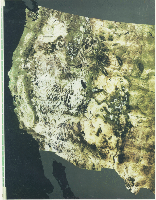
was projected through a green filter and 4 and 5 through blue and red filters). All of the western U.S. into the Great Plains beyond Denver and the Black Hills is shown. Blackish areas on land are either water bodies (such as the Great Salt Lake) or vegetated mountain slopes. Obviously, relatively little detail in the landscape is possible at this scale (~1:11,000,000) but the impression of the overall geomorphology and geologic structures that set the western U.S. apart is striking. Compare this rendition with the equivalent area in the NOAA AVHRR image presented on page 6-1.
At the other extreme, the versatility of Landsat subscene images when enlarged to show localized details is evidenced by this next image.
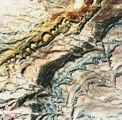
The area here, representing about 18 km (11 miles) across image base (at a scale of 1:100000), is part of a series of strata dipping to the southeast in a fold belt along the Casper Arch in central Wyoming (at the arrow point in the NGS mosaic).
The degree to which useful information from images at 30 m resolution can be extracted is explicit in a situation experienced by the writer [NMS]. In an enlargement of a TM scene containing Baltimore and Washington from which he produced a subset around Baltimore, he was able to spot the backyard of his home near Columbia, MD because of its well-watered lawn [strong IR reflectance] relative to those of neighbors on either side whose uncared-for grasses had turned brown in the summer heat. He noticed a small black spot to the south in the image which he surmised was the apron of a swimming pool at a neighbor's home three doors down, not visible to him because of a fence; when he inquired of the neighbor as to whether that pool had an asphalt apron, the "yes" answer convinced him of the power of TM to invade the "hidden" to gather arcane information. Still , the Landsat TM resolution is a far cry from that of some military "spy" systems, about which it has been claimed that license plates can be read and golf balls located on a course.
The map inset locates the main mountain subdivisions. This map was prepared by Westermann Satellite Maps; shortly after its production it became a standard aid for teaching geography to students inmany European countries.
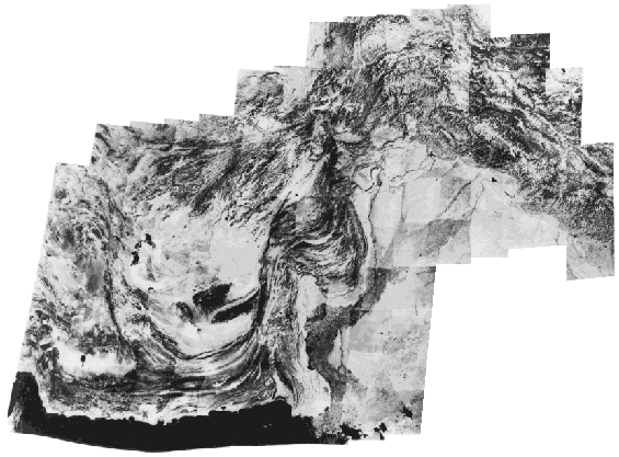
Pakistan Landsat Mosaic
The region displayed in this black and white red band mosaic includes nearly all of Pakistan, part of eastern Iran and southern Afghanistan, and a smaller segment of India, extending over about 2100 km (1300 miles) from west to east. The principal structural features are drawn on the locator map below.
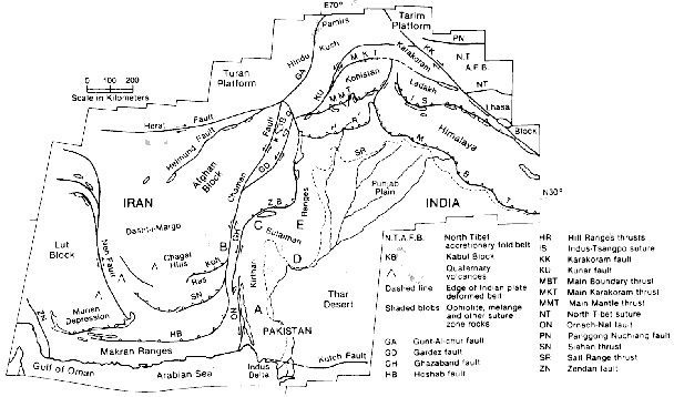
The continuous mountain belt starting with the E-W Makran Ranges, then the north-trending Kirthar and Sulaiman Ranges in Pakistan, and the great bend of the Hindu Kush joining the NW-trending western Himalayas is the consequence of the monstrous, still continuing collision of the Indian subcontinent over the last 130 million years as it drifted north to strike the underbelly of Asia along a vast subduction zone.
The ability to produce mosaics from high resolution imagery such as Landsat opens up a new dimension in the study of the Earth's land masses at continental and regional scales.
As displayed on your screen much of the detail from this resolution is lost but when a large space photomosaic is prepared either at the scale (1:,1,000,000) at which it is normally printed or is moderately reduced (say, to 1:2,500,000) to keep it manageable in size, most of the original information is retained. The chief users of mosaics like those shown above are geographers, structural geologists, and geomorphologists, all of whom benefit from the panoramic vista afforded by seeing local features in a regional context.
These mosaics also dovetail nicely with the lower resolution views of continents at the hemispherical scale provided by meteorological satellites such as Nimbus and GOES (see Section 14).
Code 935, Goddard Space Flight Center, NASA
Written by: Nicholas M. Short, Sr. email: nmshort@epix.net
and
Jon Robinson email: Jon.W.Robinson.1@gsfc.nasa.gov
Webmaster: Bill Dickinson Jr. email: rstwebmaster@gsti.com
Web Production: Christiane Robinson, Terri Ho and Nannette Fekete
Updated: 1999.03.15.