Enough of the heavy stuff for a while! Lets take a breather, have some fun and go on a simulated air vacation trip from one coast of North America to the other and pretend we can look out over large expanses of the ground. In so doing, we will gain a sense of the variety of landscapes that make this one of the most diverse and interesting continents on the globe. We will accomplish this by perusing eight Landsat TM full scenes each typifying some specific region within the 48 conterminous states. These scenes have been processed for maximum resolution and color balance by the Earth Satellite Corporation (a commercial group specializing in remote sensing services).
Many people - especially those who live near the East or West Coast of the United States - have flown on commercial aircraft across this country. Those who looked frequently out from a window seat were certainly impressed by the ever-changing landscape or "lay of the land". Each region has its own distinct character, expressed by combinations of topography, vegetative cover, and land use/cultural patterns. These, in turn, are largely controlled by the underlying geology, climate, population densities, and particular modes of development of the infrastructure supporting human activities.
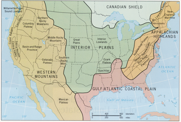
Some of you have been introduced to these ideas and relationships if you have taken a course in Physical Geography. One element or theme in that course is the importance of physiography, a term which connotes "description of the landscape" at regional scales that takes into account the types and influence of landforms, soils, climate, vegetation, and hydrologic actions on the natural appearance of the scenery giving each region its distinguishing character. Each such realm is singled out as a discrete physiographic province which, once lived in, seems to have its own visual "flavor" such that one always senses a distinctiveness in the surroundings when visiting a particular province. A map of the physiographic provinces in the 48 United States is shown below:
 |
| From H.J. de Blij and Peter O. Muller, Physical Geography of the Global Environment, Figure 52-1, 1st Ed. © 1993. Reproduced by permission of John Wiley & Sons, Inc., New York. |
Five of the six mega-provinces in North America (excluding the Arctic Coastal Plains) extend into the U.S. Three regions are subdivided by two or more provinces, as named. The Canadian Shield is part of the ancient craton or core of the continent and is marked by a dominance of Precambrian * igneous and metamorphic rocks which give rise to low hills and subdued ranges; being in the north, the colder, generally humid climate favors dense boreal forests with evergreens and birch. The dominant mega-province in eastern N. America is the Appalachian Highlands, consisting of several provinces containing rocks in age ranging from about 570 to 245 million years (m.y.) that have been involved in several major episodes of mountain building culminating in the Appalachian Revolution some 250 m.y. ago. The oldest rocks in the east, many metamorphosed and invaded by igneous intrusions, make up the Piedmont province, consisting of rolling hills and ridges. The structural bending of Paleozoic sedimentary rocks into folds often offset by faults produces a distinctive topography of dissected ridges that generally are now less than 4000 feet in elevation. This comprises the New Appalachians - also called the Valley and Ridge province. The surface has been worn down again after uplifts over the past 10 m.y to form valleys with rolling terrain. To the west is a broad area of uplifted but unfolded sedimentary rocks making up the Appalachian Plateau province. Over much of this province, erosion has carved out mountainous terrain comparable in relief to the adjacent Valley and Ridge. Being in a humid, often warm climate the Appalachians are still heavily forested with deciduous trees except where cleared by man for development.
The Interior Plains are underlain by mostly sedimentary rocks as old as 600 m.y. and young as 10-20 m.y. (in the western parts). These rocks are almost everywhere flat to subhorizontal so that erosion has not carved out prominent mountain landscapes and the terrain is furthered flattened in the northern half by deposits from continental glaciers that penetrated the upper parts during the last 3 million years. The Interior Lowlands seldom reach elevations above 460 m (1500 ft). They now support forests that remain after much was cleared into farmlands. These mostly deciduous treescapes diminish to the west and south as grasslands take over. The Great Plains section consists of deposits of sediment brought in from the Rocky Mountains to the west piled up such that the elevations increase westward to 1525+ m (~5000 ft). Most of this land is given to either natural grass rangeland used for grazing or to farming, with forests now small and scattered. In the southern U.S., but extending northward to New Jersey, is the mega-province of the Gulf-Atlantic Coastal Plain, a flat lowlands of nearly horizontal rocks laid down in the last 60 m.y. as marine waters repeatedly invaded the North American continent during variations in sea level. This region is predominantly given over to farming, although some parts remain forested.
The Western Mountains are actually a number of diverse rock/structural units of differing ages and histories of orogeny (mountain-building) with the last major events becoming progressively younger going westward. Because of differences in structural state, it is convenient to break the eastern segment known as the Rocky Mountains, which can reach heights up to 4420 m (14500 ft), into three sections. The Colorado Plateau is an elevated (typically around 1200 m [4000 ft]) uplift of still largely horizontal rocks which have been cut into spectacular landscapes mostly covered with sparse desert vegetation. The Basin and Range province consists of rugged, often barren rock bodies uplifted along faults into elongate mountains separated by valleys with gentle sloping floors representing erosional fill from the higher ranges; vegetation is mainly desert types that can be scanty compared with rocky soils that dominate the surface. The Columbia Plateau is a region capped by volcanic flows (mostly basalts) extruded from fissures over the last 40 m.y. In places the flattish land is cut by deep canyons but also is broken by older rocks sticking upward as pre-existing mountains that were not engulfed by the flows (which can be upwards of 1200 m [4000 ft] in thickness). The landscape in much of California and the western parts of Oregon and Washington is also largely mountainous. The high Sierra Nevada is a great tilted fault block rising as high as 4420 m (14500 ft) and supporting firs and pines; it passes into the Cascades which are marked by numerous stratovolcanoes more or less active in the last 20 m.y. Along the present coastline of the Pacific are the Coast Ranges, still actively being warped by plate tectonic-driven compression. In California, between these mountain belts, is the Central Valley (subdivided into the Sacramento [north] and San Joaquin [south] valleys), a structural basin now receiving infill from the highlands; its warm temperate climate allows extensive farming.
To provide you with a visual overview of the entire country, we have chosen to display a mosaic of Nimbus AVHRR false color images (see Section 14 for a description of this sensor and its satellite platform).
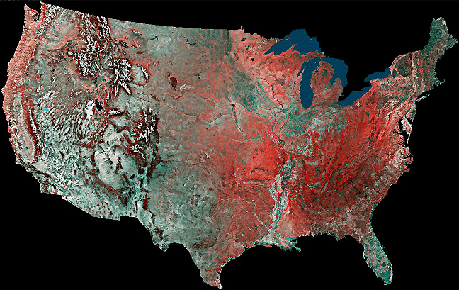
Alternatively, we could have reproduced one of several Landsat mosaics, such as the color versions produced by General Electric (that made for the National Geographic Society to celebrate the 1976 Bicentennial was in quasi-natural color [vegetation green]) or the first ever (in black and white) put together by the Soil Conservation Service. But, at the small scales needed to portray the U.S. from coast to coast, resolution is not a critical factor; instead, the AVHRR mosaic required fewer individual images and had less problems in finding individual images that are cloud-free.
* In several previous Sections, here in 6, and later in the Tutorial, geologic time units, such as the Precambrian, will be used routinely. If you are unfamiliar with this scale, and Era, Period, and Epoch terms associated with it, you can examine a simplified scale by clicking here.
Code 935, Goddard Space Flight Center, NASA
Written by: Nicholas M. Short, Sr. email: nmshort@epix.net
and
Jon Robinson email: Jon.W.Robinson.1@gsfc.nasa.gov
Webmaster: Bill Dickinson Jr. email: rstwebmaster@gsti.com
Web Production: Christiane Robinson, Terri Ho and Nannette Fekete
Updated: 1999.03.15.