 [an error occurred while processing this directive]
 [an error occurred while processing this directive]

SECTION 1
IMAGE PROCESSING AND INTERPRETATION:
MORRO BAY, CALIFORNIA
Assuming that you have read the preceding Introduction to remote
sensing, you should be ready to work along with us in this Tutorial
by putting into practice some of the basics that image interpreters
apply to examining and analyzing an image of a small part of Earth
as seen from space. We will concentrate almost entirely on analyzing
a single Landsat image. Because this will be a major learning
experience for most, this image and its derivatives will be more
intensely scrutinized than most of the others that follow in later
Sections. Several of the routine analysis techniques used in computer processing of satellite remote sensing data will be demonstrated
and evaluated (see end of page 1-16 for a brief list of text-type books covering the principles of this application of image processing). For this subscene, Idrisi will be the processing
software used to generate all image products (see bottom of page 1-13 of the Introduction Section) .
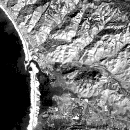
TM Band 3 of Morro Bay, California
The chosen subscene lies along the central California coast about
half way between San Francisco and Los Angeles, in the county
of San Luis Obispo. This subscene was extracted from Landsat 5
Thematic Mapper scene 5026-31810 (Path 043; Row 035) acquired
on November 19, 1984. The actual data set used is part of the
Education sampler offered to users by the Earth Observation Satellite (Eosat) Corp., 4300 Forbes Blvd., Lanham,
Maryland 20706 (the company has now merged and is known as SpaceImaging-Eosat).To acquaint yourself with this scene, look now at the black and
white TM Band 3 image which can be brought up to its full size
by clicking on it .
 |
TM Band 3 |
The data display consists of a 512 x 512 pixel array (since each
pixel represents 30 m on a side, you should be able to calculate
mentally the image scale: each side of the image is just over
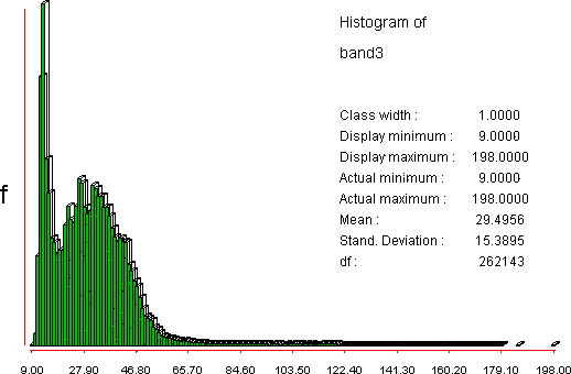
16 kilometers [10 miles] in length). Below is a histogram giving
a frequency distribution of the brightness values in Band 3. One
peak near a DN value of 9 corresponds to the dark tones associated
with the ocean; the second peak near 28 relates to the medium
gray tones.
The largest town in the image is Morro Bay, a resort community
of about 10000 permanent residents, some of whom are still actively
involved in commercial fishing. The town is located about 21 km
(14 miles) NW of the city of San Luis Obispo, reached along the
conspicuous road evident in the scene - the famed coastal Highway
1 which rambles along much of the California coastline but in
this scene extends inland to the east. The second major road,
California Highway 41, is visible as it passes through a valley
between hills enroute to Atascadero 27.5 km (17 miles) to the
NE. Cayucos is a small residential town along the coast just north
of Morro Bay. Near the bottom of the image is another large settlement,
the town of Los Osos (and adjacent to its north, Baywood Park)
which is popular now as a retirement community - especially the
areas that lie along hillsides with commanding views of the ocean.
[an error occurred while processing this directive]
[an error occurred while processing this directive]
Code 935, Goddard Space Flight Center, NASA
Written by: Nicholas M. Short, Sr. email: nmshort@epix.net
and
Jon Robinson email: Jon.W.Robinson.1@gsfc.nasa.gov
Webmaster: Bill Dickinson Jr. email: rstwebmaster@gsti.com
Web Production: Christiane Robinson, Terri Ho and Nannette Fekete
Updated: 1999.03.15.
