| Mapping Toolbox | Search Help Desk |
| navigational track format | Examples See Also |
Describe waypoints of a navigational track
Description
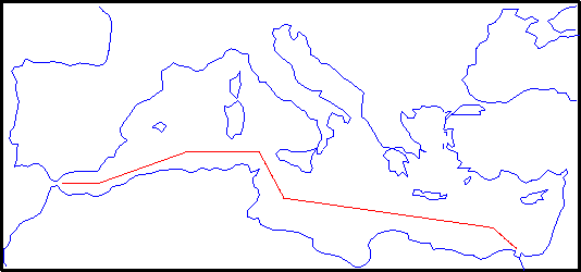
Track waypoints put into latitude and longitude column-vectors are said to be in navigational track format. Waypoints are points through which a track passes, usually corresponding to course or speed changes. A navigational track is made up of the line segments connecting these waypoints, which are called legs. In navigational track format, n legs are described using n+1 waypoints. For Mapping Toolbox navigation functions, angle units are always in degrees. See the section entitled "Conventions for Navigational Functions" in Chapter 5 of the Mapping Toolbox User's Guide for more information on unit formats for navigation functions.Examples
The waypoints of the following track, in navigational track format, are:waypoints = [36 -5; 36 -2; 38 5; 38 11; 35 13; 33 30; 31.5 32] waypoints = 36.0000 -5.0000 36.0000 -2.0000 38.0000 5.0000 38.0000 11.0000 35.0000 13.0000 33.0000 30.0000 31.5000 32.0000
See Also
dreckon |
Compute dead reckoning positions for a track |
gcwaypts |
Find equally-spaced waypoints along a great circle |
legs |
Find courses and distances between waypoints |
navfix |
Mercator-based navigational fixing |
track |
Connect navigational waypoints with track segments |