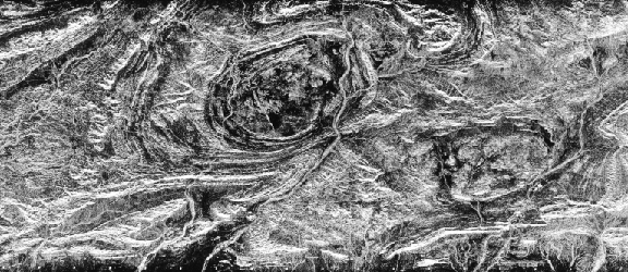
Somewhat simpler, but still intriguing, geology is displayed as the basaltic volcanic calderas Volcan Alcedo (top) and Sierra Negra (left center) on Isabela Island, the largest of the Galapagos.
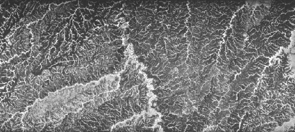
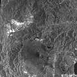
Below, the remarkable display of dendritic drainage in the SIR-A image of east-central Columbia results from uplands covered with grass that (because the blades are small) strongly reflects away the radar beam (thus dark) whereas the streams stand out as bright because their tree-lined channels produce double bounce reflections between the smooth water and tree trunks.
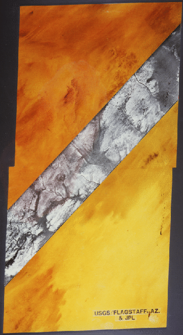
One of the properties of radar pulses gave rise to an extraordinary image acquired from SIR-A in November of 1981. The color scene below is a Landsat subimage of the Selma Sand Sheet in the Sahara Desert within northwestern Sudan. Because dry sand has a low dielectric constant, radar waves can penetrate these small particles to depths of several meters (about 10 feet) or more. The inset radar strip trending NE actually images bedrock at that general depth below the loose alluvial sand and gravel which acts as though almost invisible. A channeled subsurface topography is revealed, with valleys correlative to specularly reflecting surfaces and uplands shown as brighter.
SIR-B was operated in 1984 over 8 days aboard another Shuttle
mission. It differed from SIR-A in having a variable look angle
that ranges between 15 and 55 degrees. In April and October of
1994, a more versatile system was flown twice on Shuttle missions.
This consisted of JPL's SIR-C, which had L and C band radars,
each capable of HH, VV, HV, and VH polarizations, and an X-band
(X-SAR) instrument, supplied by German and Italian organizations,
that was in the VV mode. All had variable look angles that image
sidewards between 20 and 65 degrees, producing resolutions between
10 and 25 meters. One advantage of this multiband system is the
ability to combine different bands and polarizations into color
composites. You can examine the general way in which this is done
by clicking here as a link to JPL's SIR-C Web Site, which contains a wealth of
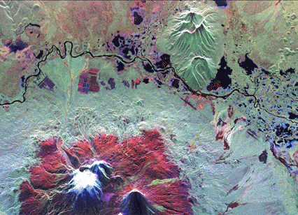
information and imagery, including this set of images showing the Kliuchevskoi Volcano
in Kamchatka (Russian Siberia) as captured by SIR-C in 3 polarization
modes.
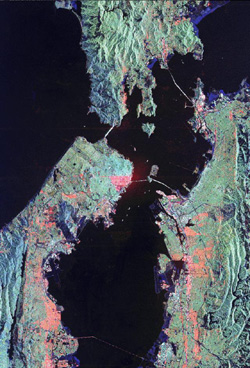
Then, you should also find this multiband (multifrequency)
image of San Francisco made from L Bands HH (red) and HV (green) and C Band HV (blue)
one of the most pleasing to the eye and a prime example of why
so many people want to live in the Bay Area after visiting it.
SIR-C radar imagery taken on two dates (or with two antennae)
can be processed using interferometric techniques that use signal
phase differences to determine differences in distance to point
targets to yield information on topographic variations. When combined
with Digital Elevation Model (DEM) data (see Section 11), single
band or color composite radar images can be shown in perspective
views (also, Section 11), as analglyphs (requiring stereo color
glasses), or even in simulated flyby video "movies". A perspective
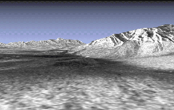
view of Death Valley and adjacent mountains made from SIR-C imagery is a good example.
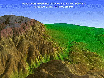
In conjunction with the SIR-C program, JPL flies an airborne system called AIRSAR/TOPSAR, from which a multiband perspective view of the mountains just north of JPL's home in Pasadena, Calif. is here presented.
Both the Europeans and Japanese have now flown radars on unmanned space platforms. Some information about the European mission is included in JPL's Radar Home Page under the topic
Earth Resources Satellites (ERS). The European Space Agency (ESA) launched ERS-1, with a complement of different sensors, in July
of 1991, at a nominal altitude of 800 km (500 miles). Along with
a radar scatterometer, it carried a C band VV SAR with a fixed
look angle extending from 20 to 26 degree that covered a swath
width of 80 km (50 miles) with a median resolution of 26 m. A
typical product is this (artificially coloured) image of the Cote d'Azur on the French Riviera.
A nearly identical
SAR was included on ERS-2 launched in April, 1995. Innovative
color composites can be constructed from the single band, single
polarization radar by using images from different dates. This
is exemplified by a multi-date image of Sevilla, Spain, in which an ERS-1 on Nov. 3, 1993 is assigned to red; an ERS-1
image on June 9, 1995 is green, and an ERS-2 image on June 10,
1995 is blue. The city of Seville appears in a cyan tone in the
upper right, as does the Sierra de Aracena in the upper left,
and agricultural fields (bright; barren) show as red elsewhere.
JERS-1, launched to a 570 km (356 miles) orbit on February 11,
1992 by the Japanese National Space Agency, contained both a 7-band optical sensor and a SAR. The latter
is L band HH, with a fixed look angle view between 32 and 38 degrees,
yielding a swath width of 75 km and a mean resolution of 18 m.
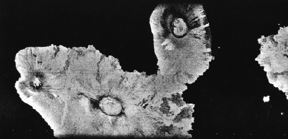
One of its first images covered Mt. Fujiyama (volcano) west of
Tokyo, as seen here.
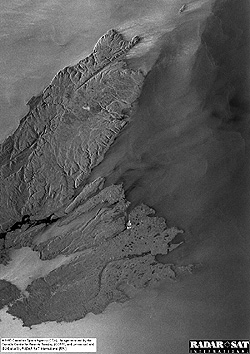
As part of its ongoing program, the Canadian Space Agency on November 4, 1995 launched its first Radarsat into a near-polar orbit at a height of 798 km (~500 miles). This
is a C band SAR whose look angle can range between 20 and 50 degrees
to provide swath widths between 35 and 500 km (22 to 310 miles)
providing variable resolution centering around 25 m. The first image collected covered Cape Breton in northern Nova Scotia. As with
most of the other systems previously described, images from Radarsat
can be converted using separate topographic data into perspective
diagrams.
The advent of radar systems into space, following their effective demilitarization worldwide, provides the remote sensing communities with a powerful source of environmental and mapping data that are obtainable over any part of the orbited Earth. With altimeter or interferometric processing, radar presents a new capability for generating topographic maps for parts of the global land surface viewable from near-polar orbits. Information on several aspects of ocean surface states is also a valuable payoff. The prospects of using multi-frequency, multi-polarization beams to obtain distinctive radar signatures offers another means to determine materials separable on the basis of dielectric constants, surficial roughness, and other properties.
Code 935, Goddard Space Flight Center, NASA
Written by: Nicholas M. Short, Sr. email: nmshort@epix.net
and
Jon Robinson email: Jon.W.Robinson.1@gsfc.nasa.gov
Webmaster: Bill Dickinson Jr. email: rstwebmaster@gsti.com
Web Production: Christiane Robinson, Terri Ho and Nannette Fekete
Updated: 1999.03.15.