Antennae for aircraft imaging radars are usually mounted on the underside of the platform so as to direct their beam off to the side (SLR) of the airplane in a direction normal to the flight path.** For aircraft, this mode of operation is implied in the acronym SLAR, for Side Looking Airborne Radar. A real aperture SLAR system operates with a long (~5-6 m) antenna usually shaped as a section of a cylinder wall. This type produces a beam of noncoherent pulses and utilizes its length to obtain the desired resolution (related to angular beamwidth) in the azimuthal (flight line) direction. At any instant the transmitted beam is propagated outward within a fan-shaped plane perpendicular to the flight line.
A second type of system, Synthetic Aperture Radar (SAR), is exclusive to moving platforms. It uses an antenna of much smaller physical dimensions, which sends forth its signals from different positions as the platform advances, simulating a real aperture by integrating the pulse "echoes" into a composite signal. It is possible through appropriate processing to simulate effective antennae lengths up to 100 meters or more. This system depends on the Doppler effect to determine azimuth resolution. As coherent pulses transmitted from the radar source reflect from the ground to the advancing platform (air- or spacecraft), the target acts as though in apparent (relative) motion. This motion results in changing frequencies, which give rise to variations in phase and amplitude in the returned pulses. These data are recorded for later processing (employing optical [using coherent laser light] or digital correlation methods), in which the moderated pulses are analyzed and recombined to synthesize signals equivalent to those obtained by a narrow beam, real aperture system.
Let us now consider the beam characteristics of a typical radar system as well as the nature and interpretation of the signal returns as displayed on film or a monitor, as described in the following illustration (from Sabins, 1987):
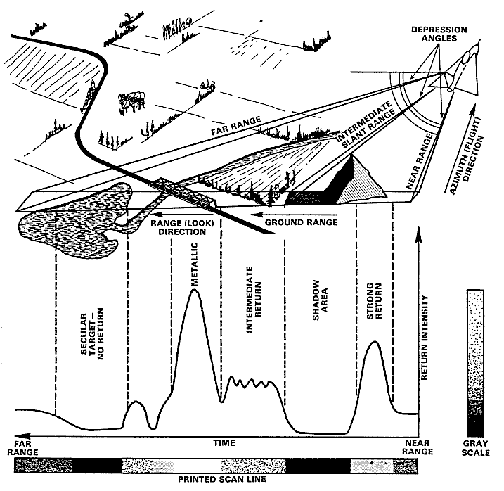
The upper half of this figure depicts a strip of land surface being scanned by the radar beam. The aircraft moves at some altitude above the terrain in an azimuthal direction while the pulses spread ouward in the range (look) direction. Any given line-of-sight from the radar to some ground point within the terrain strip defines the slant range to that point; the distance between the aircraft nadir (directly below) line and any ground target point is its ground range. The outward point closest to the aircraft flight trace, at which sensing begins, establishes the near range limit; the pulsed point at the greatest distance normal to the flight path fixes the far range. The angle between a horizontal plane (essentially, parallel to a flat surface) and a given slant range direction is called the depression angle for any point along that directional line; the complementary angle (measured from a vertical plane) is referred to as the look angle (a good mnenonic is "look up - depress down"). The incidence angle at any point within the range is that between the radar beam direction and a line perpendicular (normal) to the surface which can be inclined at any angle (which varies with slope orientation in non-flat topography). The depression angle decreases outward from near to far range. Pulse travel times increase outward between these limits. The duration of a single pulse determines the resolution at a given slant range. This range resolution (effectively, the minimum distance between two reflecting points along the azimuthal direction at that range at which these may be sensed as separate and distinct) gets poorer outward for a specific pulse duration; thus the resolution increases with increasing depression angles (highest, close-in).
The variations in pulse intensities of signals returned from the target features within the beam-swept strip are plotted in the lower half of the above figure. The pulses on reaching the target will undergo varying degrees of backscattering. A smooth, or specular, surface at low angles to the look direction (subparallel) will scatter most of the pulses away from the receiver; in effect, this reflects most of the signal away, so that its image expression is dark. A rough surface, in contrast, scatters the pulse beam over a wide range of directions, a fraction of which returns to the radar, the degree determining the relative lightness of image tone. The amount of returned energy (as backscatter "echoes") also depends on the size of the target relative to signal, with those objects with dimensions similar to the wavelength appearing bright (as though rough) while smaller ones are dark (smooth).
Note first the intensity peak in the tracing associated with the steep slope of the mountain side facing the passing aircraft. At this low incidence angle, a significant part of the transmitted pulses is reflected directly back to the receiver. However, the beam fails to reach (illuminate) the opposing mountain slope (back side) leading to no return (black) from this shadowed area or if the slope is so inclined as to receive some illumination at high incidence the returned signal is weak (dark grey). As the depression angle decreases, the next feature encountered is vegetation, which typically consists of irregular-oriented surfaces, with some leaves facing the radar and others in different positions. These objects in the plant together behave as somewhat rough and diffuse surfaces, scattering the beam but also returning variable signals of intermediate intensities. The metal bridge, with its smooth surfaces, is a strong reflector (buildings, with their edges and corners, also tend to behave that way but the nature of their exterior materials somewhat reduces the returns). The lake, with its smooth surface, functions as a specular reflector to divert most of the signal away from the receiver in this far range position. Smooth surfaces at near range locations will return more of the signal.
The signal trace shown in the figure represents a single scan line composed of pixels each corresponding to a resolution-determined area on the ground. The succession of scan lines produces an image by varying either the light intensities on a display (itself made up of screen-resolution pixels), or the density levels in a film, in proportion to the signal intensities. On either film or conventional black and white monitors, strong intensity peaks are assigned light tones and weak returned signals are rendered dark.
Code 935, Goddard Space Flight Center, NASA
Written by: Nicholas M. Short, Sr. email: nmshort@epix.net
and
Jon Robinson email: Jon.W.Robinson.1@gsfc.nasa.gov
Webmaster: Bill Dickinson Jr. email: rstwebmaster@gsti.com
Web Production: Christiane Robinson, Terri Ho and Nannette Fekete
Updated: 1999.03.15.