 [an error occurred while processing this directive]
 [an error occurred while processing this directive]

SECTION 8
RADAR AND MICROWAVE REMOTE SENSING*
Radar Defined
Radar is an acronym for Radio Detection and Ranging. Radar operates in part of the microwave region of the electromagnetic spectrum, specifically over the frequency interval from
40000 to 300 megahertz (MHz), the latter extending just into the
higher frequency end of the radio (broadcast) region. Commonly
used frequencies and their corresponding wavelengths are specified
by a band nomenclature, as follows: K-alpha Band: 40000-26000
MHz (0.8 - 1.1 cm); K Band: 26500-18500 MHz (1.1 - 1.7 cm); X
Band: 12500-8000 MHz (2.4 - 3.8 cm); C Band: 8000-4000 (3.8 -
7.5 cm); L Band: 2000-1000 MHz (15.0 - 30.0 cm), and P Band: 1000-
300 Mhz (30.0 - 100.0 cm). Unlike other sensors which passively
sense radiation from targets illuminated by the Sun or thermal
sources, radar generates its own illumination (hence, it is active;
another example is the flash camera) as bursts or pulses of energy
directed to the target and then sensed as fractions of the energy
returned. Thus, a radar system is a ranging device that measures distances as a function of round trip travel
times (at light speed) of a directed beam of pulses (the signal,
whose strength is measured in decibels, dB) spread out over specific
distances. In this way radar establishes the directional location
and separation distances from the (either fixed or moving) instrument
to a scattering target (at any instant, a field of view corresponding
to an area on the ground surface determined by system resolution).
Information about target shapes and certain diagnostic physical
properties of materials at and just below the surface is also
derived from analysis of signal modifications.
By supplying its own illumination, radar can function during both
day and night and, for some wavelengths, without significant interference
from blocking atmospheric conditions (e.g., clouds). These characteristics
prompted development of radar in World War II as a dynamic range
finder for tracking aircraft and ships; both ground (fixed) and
airborne (mobile) radar systems are used extensively today for
marine navigation and air traffic control. Imaging radar mounted
on air or space platforms has proven especially useful in mapping
cloud-shrouded land surfaces (a landforms map of Panama used this
approach); this also permits expression of the surface shapes
in regions heavily covered by vegetation ("penetrated" by some bands).
This ability to "mirror" ground surfaces to display topography
is a prime use of radar operating on moving platforms. This is
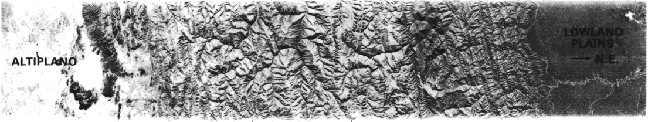
strikingly confirmed in the radar image strip (SIR-A system on
the Shuttle; see below) shown here that extends 200 miles (300
km) to the northeast (right side) across the folded and dissected South American
Andes in Bolivia from the high plains (Altiplano) on the west
to the lowlands (Amazon Basin)on the east. (Scroll to see this right end.)
Radar (as well as passive sensors operating at microwave wavelengths
straddling or outside those used by radar) is also effective in
detecting soil moisture and sea states.
* This unit is adapted and expanded from the section on Radar Systems (pp. 367- 374) in the Landsat Tutorial Workbook, NASA RP 1078, 1982. For an excellent, up-to-date review of Imaging Radar Technology, covering both air and space systems, click on the NASA JPL Radar Page
[an error occurred while processing this directive]
[an error occurred while processing this directive]
Code 935, Goddard Space Flight Center, NASA
Written by: Nicholas M. Short, Sr. email: nmshort@epix.net
and
Jon Robinson email: Jon.W.Robinson.1@gsfc.nasa.gov
Webmaster: Bill Dickinson Jr. email: rstwebmaster@gsti.com
Web Production: Christiane Robinson, Terri Ho and Nannette Fekete
Updated: 1999.03.15.