REGIONAL STUDIES: USE OF MOSAICS
The photographs are taken in sequence such that there is always about 50% overlap (area shared in common) between each successive picture, normally accomplished by automated firing of the camera shutter at a timing interval controlled by altitude, air speed, and camera properties. On the next parallel line the navigator attempts to traverse the ground at a lateral distance that produces up to 40% sidelap. Both "laps" allow for obtaining a three-dimensional or stereo effect (see Section 11 for discussion of stereoscopic procedures and examples of 3-D views). However, the resulting pictures almost always display distortions. This is caused by such factors as wobbling of the aircraft (pitch, roll, and yaw) in flight brought about mainly by turbulence and inexact navigation. There is also a notable distortion in an image outward from its center (presumed looking vertically downward but at times a tad off center) owing to the increasing slant distances from center to edge. This effect decreases with higher altitudes and can also be diminished by adjustments of focal length and other camera geometry. There also can be a discernible reduction in tonal brightness from the interior of the photo towards its boundaries.
In practice, mosaics are constructed from the central parts of the component photographs which are trimmed enough to remove the more distorted shared outer parts. They thus approximate rectified orthophotos. Large photo-mosaics have an added problem. The flight lines used in their production are frequently flown on different days (or, less commonly, at a different time of the same day) so that lighting and weather conditions often are not uniform (especially if the overflights are scheduled weeks apart, in which case vegetation has changed, along with seasonal shifts in sun orientation). Some of these deviations can be compensated for by photographic processing but uncontrolled (minimal adjustments) mosaics are typically rather patchy.
To retain maximum resolution, a photo-mosaic must be put together from individual scenes that have not been reduced in size. Consider making a mosaic from aerial photos having a scale of 1:62500. Each photo, approximately 12 inches on a side, covers almost 1 square mile of ground surface. To effect a mosaic representing ground dimensions of 2500 square miles (50 miles on a side), the end result would be a "billboard" 50 feet wide and high (requiring 2500 photos, neglecting trimming requirements). This is impractical, so that mosaics almost invariably are reduced in size and hence in scale (defined in Section 10) and therefore have a notably reduced resolution.
The scene below is a solid example of a typical uncontrolled mosaic. This is a series of high-altitude U-2 photos (each about 18 km [12 miles] on a side) taken by NASA along 7 flight lines during late spring of 1972 in support of the writer's study of the geology of central Wyoming.
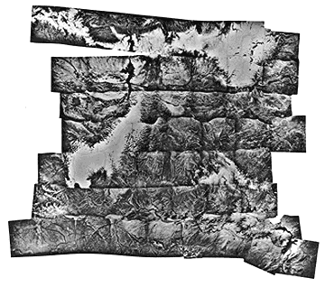
Compare this scene, centered on the Wind River Basin, with the Landsat image covering the area just to the west, seen on p. 2-8, which shows the Basin in the right center. The Owl Creek Mountains, with partial snow cover, lie along the top; the Sweetwater River is at the bottom; a cloud bank appears in left center. This black and white scene shows more ground detail, even in the black and white mode, than does a Landsat full image but the even-toned nature of the latter compensates somewhat for the information quality. The mosaic here has several of the problems inherent to aerial products. The amount of sidelap was minimal, so the pictures could not be trimmed. The inherent average gray levels darken from the central area of each picture, such that the boundaries between photos are emphasized. Exact joins are difficult owing to edge distortions. This gives the mosaic an overall blocky or patchwork appearance that detracts somewhat from its presentation of the feature content.
Code 935, Goddard Space Flight Center, NASA
Written by: Nicholas M. Short, Sr. email: nmshort@epix.net
and
Jon Robinson email: Jon.W.Robinson.1@gsfc.nasa.gov
Webmaster: Bill Dickinson Jr. email: rstwebmaster@gsti.com
Web Production: Christiane Robinson, Terri Ho and Nannette Fekete
Updated: 1999.03.15.