Most of the landmarks to be described can be picked out in this high-altitude aerial oblique image taken by a camera onboard a NASA U-2 aircraft. The view from this perspective looks east-northeast from a point over the Pacific Ocean. In the distance are the snow-capped Sierra Nevadas and the Sacramento Valley. Try to match specific features in this IR photo (which, incidentally, is blue-dominated because the sky blue effect was not compensated by a haze filter) with their counterparts in the Landsat image.
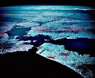
The Central Valley, known in its northern half as the Sacramento Valley (southern half is the San Joaquin Valley), is one of the great agricultural regions of the world. The numerous farms visible in the above imagery attest to this dominant land use. Cash crops include beans, cotton, rice, barley, and sugar beets. Stockton and Modesto are the two large valley towns.
The Coast Ranges are the most recent products of still active orogeny that results from the collision between the Pacific and North American lithospheric plates. The mountains consist of granular (clastic) sediments in places metamorphosed by high temperatures and pressures or intruded by igneous magmas. Their rocks have been severely deformed but the ranges generally rise only a few thousand feet above Pacific sea level. Passing near the coast but inland is the great wrench (horizontal movement) fracture known as the San Andreas Fault (look for the abrupt termination of red [from California oaks, redwoods, and other vegetation] in the mountains south of San Franciso) - the plane dividing the north-moving Pacific side of the crust from the more static North American side.
Two embayments of the coast stand out in this image: Monterey Bay near the bottom (noted for its rich aquatic and bird life) and San Francisco Bay, which to its north becomes San Pablo Bay, along which San Francisco (west), Oakland (east), San Jose (south) and many other Bay Area towns are situated. The fault-bounded hills to the east are part of the Diablo Range which becomes progressively less vegetated towards the Great Valley (at this time of year it is covered with the same brown, dried grasses we examined in the Morro Bay subscene).
Most of San Francisco itself is displayed in grayish-blue tones that indicate a sparsity of trees in the City (rather surprising to any resident or visitor who is struck by its great beauty). The exceptions are the lush vegetation (many eucalyptus trees) in Golden Gate Park (long rectangle) and the Presidio (a now deactivated military facility). Your monitor resolution may allow you also to pick out a tine (blue) line of ships (mothballed Liberty Ships and others from World War II) right of the narrow Carquinez Straits off the east end of San Pablo Bay. In the south Bay are large patches with lighter blue or green tints. These are salt evaporating basins; the greenish ones are actually basins with red sediments (bright tones in TM 3 that thus pass green light in a transparency).
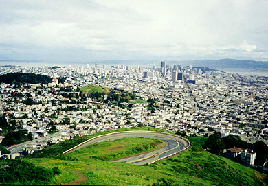
Many, including this writer (NMS), consider San Francisco to be the most beautiful city in the U.S. Here is a photo taken in 1994 by the writer that shows the central city from the tourist vista called Twin Peaks.
Lets take a closer look by enlarging the Bay Area portion of the image.
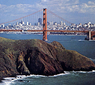
Carrying this enlargement even further to highlight the most famous bridge leading into the Peninsula, you should be able to pick out the Golden Gate Bridge. The view of "the City" through the bridge, on the right, is from the vantage of a small park on the Marin County side (at X). The Presidio and Golden Gate Park are also obvious.
;
With this, we end our transcontinental sojourn. If you have crossed the states before, you can use this tour as a reminder of what you saw. If such a trip is made in your future, this tour is a splendid preview of what you should look for. Bon voyage!
Code 935, Goddard Space Flight Center, NASA
Written by: Nicholas M. Short, Sr. email: nmshort@epix.net
and
Jon Robinson email: Jon.W.Robinson.1@gsfc.nasa.gov
Webmaster: Bill Dickinson Jr. email: rstwebmaster@gsti.com
Web Production: Christiane Robinson, Terri Ho and Nannette Fekete
Updated: 1999.03.15.