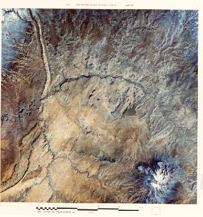
the Four Corners - the only place in the U.S. in which that many states touch each other at one point (it cannot be discretely picked out but lies about 30% up and 15% in from the lower right corner of the image).
Many people consider this the most scenic of all provinces in the U.S. because of its marvelous landforms and its colorful rocks. Many of its mainly Upper Paleozoic and Mesozoic rock units are bright reds, oranges, and yellows whereas others are light to dark gray to brown; to the southwest of this scene, the Grand Canyon - the most famous feature in the Plateau - exposes typical multi-colored units. Bryce, Zion, and Canyonlands National Parks also display spectacular colored rocks. Some of these colors are approximated in this false color January image. At this time of year the sparse vegetative cover of sage, mesquite, and grasses does not produce a typical red signature so that the surface tones are entirely those of rock and soil.
The rocks are almost everywhere still in the subhorizontal positions in which they were deposited as sediments. Because they erode back along steep faces or scarps where cap rock is hard, the layers stack like steps to form plateaus, mesas, and buttes. The Gothic Mesas, just to the right of image center, are typical. Monument Valley, a classic cluster of mesas that are often seen in movie Westerns, begins near the lower left corner. The Plateau has participated in the general deformation of the West chiefly by uplifting without folding. However, Combs Ridge, a prominent monocline (like the Waterpocket Fold) is evident about 15-20% in from the left edge of the image. Near the bottom right corner are the snow-capped Carrizo Mountains, in part volcanic in origin, which rises at Pastora Peak to 2870 meters (9420 feet); these highlands blend into the Chuska Mountains to the south just off the image.
This barren region has a very low population. Part of the scene includes the Navajo Indian Reservation. The small towns of Mexican Hat and Bluff in Utah lie along the San Juan River. At center left, this river has entrenched (deeply downcut) its meanders to produce steep canyon walls that make up the picturesque "Goosenecks". Just to the west of the image, the San Juan joins the Colorado River upstream from the artificial Lake Powell formed by the Glen Canyon Dam. Perhaps you noticed a "streakiness" in much of the lower part of the image. This is an effect of prevailing winds, re-enforced by joint (fractures) control of landscape erosion.
Code 935, Goddard Space Flight Center, NASA
Written by: Nicholas M. Short, Sr. email: nmshort@epix.net
and
Jon Robinson email: Jon.W.Robinson.1@gsfc.nasa.gov
Webmaster: Bill Dickinson Jr. email: rstwebmaster@gsti.com
Web Production: Christiane Robinson, Terri Ho and Nannette Fekete
Updated: 1999.03.15.