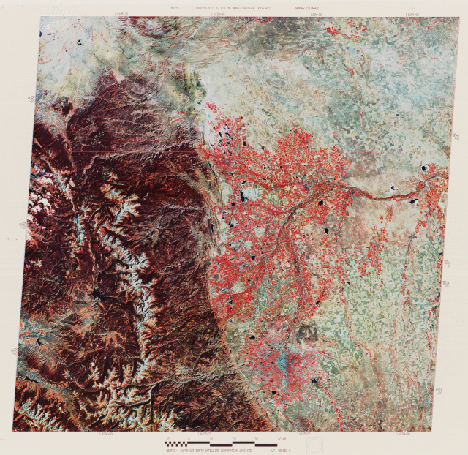
These mountains form the eastern edge of the North American Cordillera, made of groups of diverse, usually complexly folded and faulted blocks of crust uplifted or thrust against other blocks separated by structural basins. These were deformed and emplaced during periods of major orogenies that were often disconnected in time and place. Rock units in the Rockies were finally compressed and shoved upwards about 65-70 million years ago. The present topography of these mountains is the result of strong erosion thereafter that has lowered their original heights to under 4420 meters (~14,500 ft). Alpine glaciation has steepened and widened already deep valleys creating the rugged vistas that make this region especially popular for tourists and skiers. The barren (whitish) area along the crest of the Front Range coincides with the Continental Divide along parts of the mountains above treeline. Slopes below are forested with Douglas fir, spruce, pine, and aspen. Rocky Mountain National Park is found in the left center of the image. The southern end of the Medicine Bow Range in Wyoming extends into the image at top left.
Denver appears at the edge of the plains in the lower center; to the right of the bluish downtown is a large square which is the Rocky Mountain Arsenal once used for storage of military weapons. To its west, against the Mountains, are thin elongate strips with yellowish and brownish colors. These are "hogbacks" - steeply dipping sedimentary rocks inclined down to the east as the Front rocks were pushed upwards; those with yellow tones are actually reddish (the Red Rocks Park contains them) but have this color variant in the false color mode. Reds within Denver and around Boulder and Fort Collins are both trees and crops still bright in the near-IR in this October scene. Their distribution is affected by proximity to the Platte and other rivers. These rivers provide irrigation for the alfalfa, hay, oats, corn, beets, and barley grown in this part of the Plains. Uncultivated areas, such as the Pawnee Grasslands (brownish patch at right center), contain buffalo and grama grasses.
Code 935, Goddard Space Flight Center, NASA
Written by: Nicholas M. Short, Sr. email: nmshort@epix.net
and
Jon Robinson email: Jon.W.Robinson.1@gsfc.nasa.gov
Webmaster: Bill Dickinson Jr. email: rstwebmaster@gsti.com
Web Production: Christiane Robinson, Terri Ho and Nannette Fekete
Updated: 1999.03.15.