The scene now on your screen lies within the New England Maritime physiographic province.
Geologically, this region is actually a part of the Appalachian Mountain Belt that passes northward through Nova Scotia and Newfoundland. Most of the rocks underlying the province are igneous and metamorphic. Such rock types usually are associated with the deeper parts of an orogenic belt where temperatures and pressures were higher in the times over which they formed; their presence at the surface today implies extensive erosion that stripped away the overlying sedimentary rock units after the main episode(s) of mountain-building and uplift. The landscapes typical of New England resemble parts of the Canadian Shield. Flatter areas are interspersed with low mountains, although peaks such as Mt. Washington in New Hampshire and Mt. Katahdin in Maine the elevation exceed 1890 m (6200 ft) and 1590 m (5200 ft) respectively. The rocky soils in the region do not favor farming, so that much of the land remains in forests (the predominance of deciduous trees accounts for the widespread reds in this false color composite). Most of New England experienced one or more advances of the Pleistocene continental glaciers that removed soils, laid down deposits, and carved out lakes.
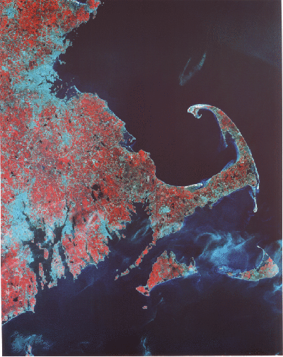
The most conspicuous feature in this scene is Cape Cod, an East-West trending landmass built from extensive end morainal deposits marking advance lines of glacial ice sheets. The sharp bend ending at Sandy Hook represents in part modifications brought on by ocean wave action. South of the Cape are the islands of Nantucket and Martha's Vineyard, also of fluvioglacial origin. Lowlands associated with drowned rivers make up Buzzards Bay off the west end of the Cape and Narragansett Bay below Providence in Rhode Island. The bluish area up the Massachusetts coast is the central part of greater Boston whose harbor lies against Boston Bay.
Code 935, Goddard Space Flight Center, NASA
Written by: Nicholas M. Short, Sr. email: nmshort@epix.net
and
Jon Robinson email: Jon.W.Robinson.1@gsfc.nasa.gov
Webmaster: Bill Dickinson Jr. email: rstwebmaster@gsti.com
Web Production: Christiane Robinson, Terri Ho and Nannette Fekete
Updated: 1999.03.15.