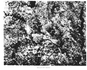
What you are seeing is Dallas, Texas near the center and a bit of Fort Worth along the left edge. The Trinity River runs through downtown Dallas towards the lower right. Interstate 20 passes E-W near the bottom of the scene and Interstate 30 follows subparallel to it in the left center. I-20 is joined by I-635 on the east but in this scene one can see that the latter is not yet completed. Also, the white area in left center is the partially completed Dallas-Forth Worth International Airport.
The problem in identifying the location was that the Atlas being used was rather out-of-date. Several reservoirs and lakes clustered around D-FW built since its publication were thus not depicted in the Atlas, although several that appear in this subscene (elongate black patterns) were shown. Thus, no one at the outset was able to match the broader Polaroid pattern to this incomplete map pattern with satisfactory certainty. Eventually, some "wise men" deduced that this was the cause of the misfit and Dallas-Forth Worth officially was recognized as the inaugural Landsat scene (although, in fact, the first full black and white scene to be viewed later that day was a stunning cloud free image of the Ouachita Mountains in eastern Oklahoma and the first color composite covered the Monterey Bay to San Joaquin Valley section of California).
We reproduce that false color composite here, both for its historical significance and because the first version, seen here, serves as a "collector's item" because of a production quirk.
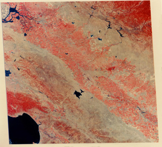
Before reading on, look at this image to see if you can see the obvious anomaly. You might want to look again at the full scene images of New York City to refresh your awareness of image shape.
Remember that this shape is necessarily that of a rhomb with the upper part tilted to the right. This is the consequence of the fact that the Earth is turning (counter-clockwise or W to E) under the spacecraft as it descends from north to south. Each successive scan sequence is shifted slightly to the west. When processed, the image must express this by its up-down boundaries being moved progressively to the left. Somehow, this was not done correctly as the technicians rushed to get the first color composite out to the waiting ERTS specialists, so that the upper part is tilted left instead of the usual right.
Now, lets leave "town" to journey once more into the vast countryside, this time by considering views of southwest Utah and the Plains of Oklahoma as examples of how remote sensing contributes to mineral and oil/gas exploration.
Code 935, Goddard Space Flight Center, NASA
Written by: Nicholas M. Short, Sr. email: nmshort@epix.net
and
Jon Robinson email: Jon.W.Robinson.1@gsfc.nasa.gov
Webmaster: Bill Dickinson Jr. email: rstwebmaster@gsti.com
Web Production: Christiane Robinson, Terri Ho and Nannette Fekete
Updated: 1999.03.15.