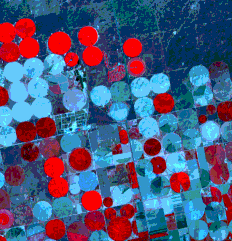
These are an effective innovation in recent decades known as center pivot irrigation systems.
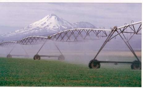
Center Pivot Irrigation System, Northern California, Mount Shasta in Background
A line of water pipes is mounted on motorized wheels and with one end fixed at the center of the field. When operating, the irrigation system is thus able to move or swing in a circle, ejecting water as it rotates. (Several fields actually show a dark linear "radius" which is this interesting system.) The red circular fields are mostly plantings of winter wheat nearing harvest; those in various shades of blue (expression of the soil; note darker patterns of moisture) are fallow at this time but most have probably been seeded for spring wheat, or will be. Note road patterns that block out squares: these are laid out along survey lines that coincide with the one-mile squares representing "sections" in the American Township and Range surveying system. The worm-like red pattern within a section in the upper center is an 18-hole golf course - seemingly in the "middle of nowhere" (compare it with the one in the Morro Bay scene).
Our final SPOT agricultural scene is actually two images of the same area obtained two months apart during late winter and spring in northwest Africa. The purpose here is to illustrate changes in vegetation as the crop calendar progresses. The area is that of the Ghard plains not far from the Atlantic coast in western Morocco near Casablanca. This "granery belt" is a main producer for that country: crops include beets, sugar cane, wheat, and rice.
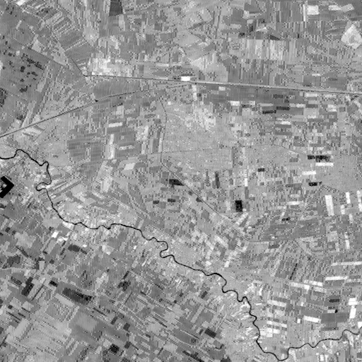
Let's start by looking at the SPOT Band 1 (green) image (above) acquired on March 14, 1986. Your first reaction should be that the landscape is mostly devoted to farming, with almost all plots being smaller than in the Kenyan and Kansan scenes. Next obvious are the small river (Oued Oum er Rbia) and the major roadway to El Jadida on the west and Settat on the east, met by several feeder roads. Three areas in bright tones just south of the highway are settled towns. Note also some very dark areas in the image.
These dark areas are nearly black in Band 3 (IR) (top). They are almost certainly bodies of water, some being irregular in shape that represent standing water from spring floods and others in field-like shapes are probably irrigated rice fields. Only a fraction of the fields (particularly along the river) are rendered in bright tones, indicating that most crops are not yet well along.
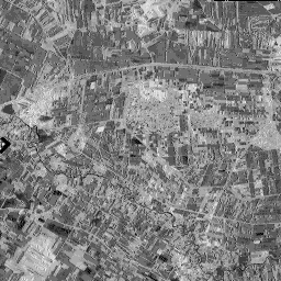
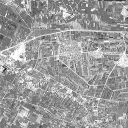
But, when the same area is imaged in SPOT Band 3 on May10, (, above, bottom) a much larger percentage of fields are in brighter tones, suggesting many crops are now underway. The black areas of flooding are reduced but rice fields remain about the same. The towns are shown in medium gray tones; the one in the center is dotted with tiny bright patches, indicating numerous trees.
The pronounced differences in extent of active vegetation, both in fields and in trees, are much more evident when comparing false color images first for the March scene (top) and then the May scene (bottom).
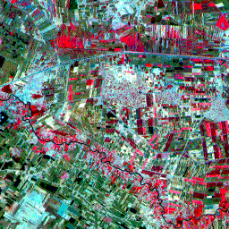
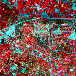
In the March image, an estimated 30% of the fields have actively growing crops; in the May image, this increases to about 80%. The areas of open water noted in the March scene greatly diminish in the May scene. Some of the areas with water show up as dark red (typical of rice) in the May view. In the March scene, a large part of the land not in growth is displayed in a darkish brownish-green color which in false color is the expression of soils that are naturally reddish-brown.
Image-processing techniques for change detection can help to emphasize major distributions of active versus dormant or absent vegetation. One simple approach involves making a ratio image the same bands, usually the IR, for two dates, one divided by the other. This results in very bright tones wherever vegetation is prevalent in the dividend date but not in the divisor date. The opposite is true if the vegetation distribution is reversed datewise. If vegetation is present to similar extents on both dates, the ratio image tones will be moderately gray. A ratio image was attempted for the March and May scenes but failed because the two scenes do not exactly coincide (being taken on different dates when the orbits were not exactly superimposed). Idrisi, while it can generate ratio images, does not have the precise program for co-registering two closely related images where one is slightly offset from the other (this involves a computer algorithm that can execute a "rubber-stretch fit").
Code 935, Goddard Space Flight Center, NASA
Written by: Nicholas M. Short, Sr. email: nmshort@epix.net
and
Jon Robinson email: Jon.W.Robinson.1@gsfc.nasa.gov
Webmaster: Bill Dickinson Jr. email: rstwebmaster@gsti.com
Web Production: Christiane Robinson, Terri Ho and Nannette Fekete
Updated: 1999.03.15.