The payload sensor on SPOT is known as the HRV (for High Resolution Visible). This is a slight misnomer, inasmuch as in its multispectral mode, Band 3 operates in the near-IR over the interval 0.79 - 0.89 µm (Band 1 = 0.50 - 0.59 µm [green] and Band 2 = 0.6 - 0.68 µm [red]). A separate unit in the HRV can also image in the panchromatic mode as a single band encompassing 0.51 - 0.70 µm. Instead of an oscillating scan mirror, the tiltable mirror (set either on or off-nadir) sends light to a linear array of tiny detectors (known as CCDs, for charged coupled devices; see p. I-13 for details on how these function), which receive photons simultaneously, that are very rapidly discharged in sequence into an electron current stream. This array is then reactivated by photons almost instantly as the array line moves to the next ground position along the forward track. In the panchromatic mode, there are 6000 detectors in the array, each receiving its light from a 10 x 10 m ground area, thus providing a resolution of 10 m for an image of 60 km (37 mile) width. The multispectral HRV contains 3000 detectors in the array, providing a ground resolution of 20 m. On the spacecraft there are two such HRV arrays, mounted side-by-side, each viewing its own 60 km swath width but the pair of images sidelapping to give an effective 117 km wide coverage.
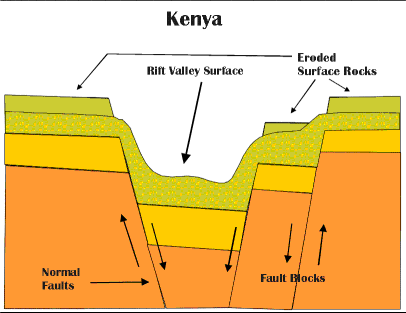
Some faults are young enough to remain relatively uneroded so that they present a steep, often abrupt face (called a scarp) separating the upthrown (upland) block from the downthrown (valley) block, as evident in the ground photos below.
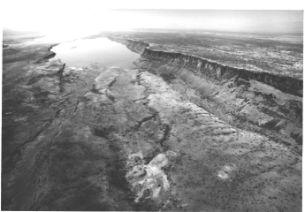
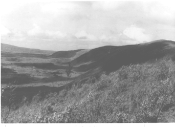
Along much of the Rift, the land is an arid, semi-desert savannah (top photo). In other segments of the rift zone, the scarp is older and more weathered back and may be covered in part with dense shrub, as in the lower (or right) photo, or forest. Most of the rift zone is underlain by a sequence of basalt (volcanic) flow units. Compare the SPOT scene that will follow with the next scene, a regional mosaic made from all or parts of 9 Landsat MSS images, of much of Kenya that extends over an area about 500 km 310 mile) wide E-W.
Consult the index map
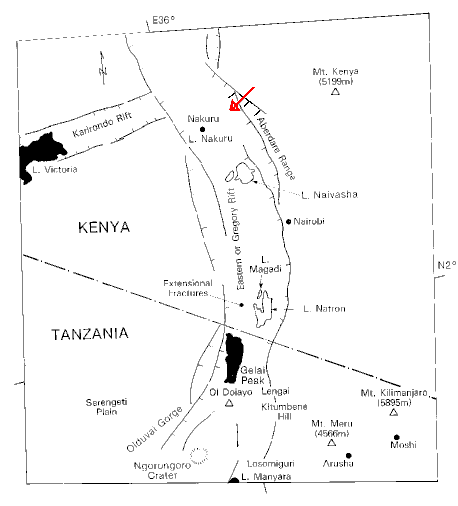
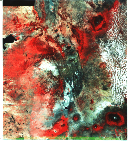
for major landmarks in this mosaic, including Mt. Kenya and Mt. Kilimanjaro in Tanzania, both over 5230 m (17000 ft) high and therefore snow-capped. The arrow points to the location of the 10 km-wide subscene below extracted from a full 60 km SPOT image produced as a false color composite.
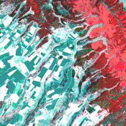
Whereas details are lacking in the mosaic, the SPOT image shows a remarkable amount of surface information. The edge of the Rift Valley passes from upper center to lower right, as marked by strong reds associated with forest lands (note the internal texture within this section which is an effect created by large tree groupings). To its right is an area of rather uniform red, without any treelike textural pattern, interpreted as grass and shrub lands. The area to the left (west) is occupied mainly by irregular-shaped fallow fields, many of which are 0.8 km (0.5 miles) or larger in long dimension. Some fields appear in this color version as almost white; others are in two dominant shades of blue. Inspection of the three individual SPOT bands (not reproduced here) shows the white fields to be nearly white in each band and the blue fields to be medium gray in Band 1, darker in 2 and very dark gray in 3. The lack of any reds in these two types of fields confirms that crop growth (mainly of coffee and wheat in this part of Kenya) is nil to early. Not having been there, we do not have any adequate explanation for this pronounced difference in tone between these fields. The dark tones could represent the prevailing color (also dark) for soils derived from the very dark basalts. But this fails to explain the nearly white tones for the other fields. They might be the signature of a grain crop, such as unharvested mature wheat, (hence bright straw yellow, and thus very reflective in bands 1 and 2 as well as the IR band); any further speculation without supporting ground truth would be frustrating. Note the pink tones in several areas of the scene including along stream courses and in the narrow stream canyons cut into the rift wall slopes. These may be due to two conditions: the foliage of some trees has only begun to develop new leaf growth in this March 14, 1986 scene and the vegetation there is experiencing some stress due to deforestation as local farmers progressively clear the land.
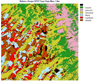 Some of the above ideas are implicit in the supervised maximum
likelihood classification of this scene in which the classes chosen
are: woods, grasses, newclear (new growth and cleared land), ltfield,
medfield, dkfield (light, medium and dark fields). The results
are quite believable in that the color patterns tend to be homogeneous
and their distributions are logical. The extent of "newclear"
is somewhat greater than the eye can discern in b & w images.
There are some black areas in the classified image. Those that
tend to be scattered are simply unclassified pixels. But several
areas have definite shapes and are probably small lakes or ponds
(flamingo breeding grounds in this region).
Some of the above ideas are implicit in the supervised maximum
likelihood classification of this scene in which the classes chosen
are: woods, grasses, newclear (new growth and cleared land), ltfield,
medfield, dkfield (light, medium and dark fields). The results
are quite believable in that the color patterns tend to be homogeneous
and their distributions are logical. The extent of "newclear"
is somewhat greater than the eye can discern in b & w images.
There are some black areas in the classified image. Those that
tend to be scattered are simply unclassified pixels. But several
areas have definite shapes and are probably small lakes or ponds
(flamingo breeding grounds in this region).
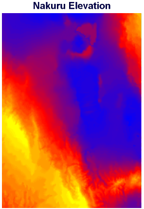
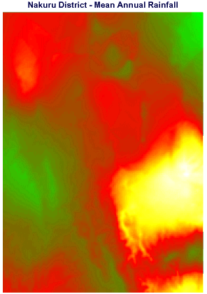
Quite by serendipity, during the preparation of this caption it was discovered that Idrisi uses two special theme maps of the Nakuru region as part of its training exercises. With permission, we repeat these here: on the top is a map of elevations (in feet, showing the Rift Valley to be as low as 5690 ft in blue, and the western uplands to reach >9850 ft in yellow), with the SPOT scene somewhere in the upper right; and on the bottom is another map which plots the annual distribution of rainfall in millimeters (green is wettest, then red, yellow, white as driest) (note: in this equatorial region of East Africa there are two rainy seasons: winter and summer). Draw your own relationships to the SPOT scene from these maps.
Code 935, Goddard Space Flight Center, NASA
Written by: Nicholas M. Short, Sr. email: nmshort@epix.net
and
Jon Robinson email: Jon.W.Robinson.1@gsfc.nasa.gov
Webmaster: Bill Dickinson Jr. email: rstwebmaster@gsti.com
Web Production: Christiane Robinson, Terri Ho and Nannette Fekete
Updated: 1999.03.15.