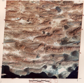
This full Landsat scene covers part of the Zagros Mountains along the southwest coast of Iran against the Persian Gulf. These mountains consist mainly of elongate folds which arch upwards as anticlines and downwards as synclines. The anticlines here make up distinct landforms as high hills with central ridges that taper at either end (a condition referred to as a closed fold).
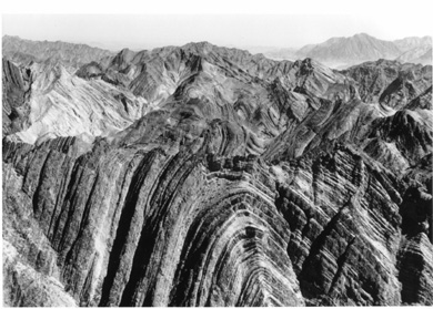
A simple analogy is to imagine cutting a watermelon in half through its longest dimension and laying it the flat cut on the floor; from above it resembles some of these Zagros anticlines; if then cut through from top to bottom at center, the exposed cross-section through green husk, white rind, and reddish center would be shaped like the folded strata within the anticlines, much like in this field photo through a Zagros fold:
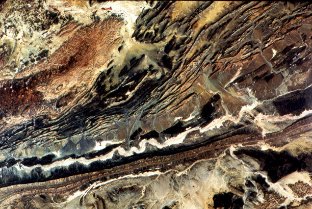
One of the best exposures of a complexly folded mountain belt anywhere occurs in the Atlas Mountain system of northwest Africa. This group is part of the great orogenic belt that includes the Alps, Appenines, the Betic Cordillera (southern Spain), and other chains that can be traced eastward through Turkey into the Zagros Mountains. These belts began to form about 70 m.y. ago, when the Tethys Ocean (precursor to today's Mediterranean) started to close as the African Plate moved northward against the Eurasian sets of plates. The orogeny climaxed in the late Cenozoic and is still active. The Landsat scene below covers part of the Anti-Atlas mountains of southern Morocco. In the upper left is a deformed and metamorphosed core of Precambrian rocks against which the tight disharmonic folds of lower to mid-Paleozoic rocks (center) have been shoved northward along thrusts. The white sinuous band against a fold ridge is a dry stream or wadi.
Code 935, Goddard Space Flight Center, NASA
Written by: Nicholas M. Short, Sr. email: nmshort@epix.net
and
Jon Robinson email: Jon.W.Robinson.1@gsfc.nasa.gov
Webmaster: Bill Dickinson Jr. email: rstwebmaster@gsti.com
Web Production: Christiane Robinson, Terri Ho and Nannette Fekete
Updated: 1999.03.15.