We shall now consider several examples of geologic applications using these new approaches. We will concentrate initially on how Landsat TM data for a local region in Utah are manipulated to identify different rock types, map them over a large area using supervised classification, and correlate their spatial patterns with independent information on their structural arrangement. Next, our focus changes to examination of geologicstructures, particularly lineaments, as displayed in regional settings in the U.S., Canada, and Africa. Then, in Section 5, we will look at how space-acquired data fit into current methods of exploring for mineral and hydrocarbon deposits by considering a case study of a mineralized zone and at a large area Landsat scene in Oklahoma. In Section 18, we will return to a geologic theme by examining landforms at regional scales - so-called mega-geomorphology - as the principal subject in considering how remote sensing is being used in basic science studies.
Most geologic maps are also stratigraphic maps, that is, they record the location and identities of sequences of rock types according to their relative ages. The fundamental rock unit is the formation, defined simply as a distinct mappable set of rocks (if sedimentary, then usually layered) that has a specific geographic distribution. A formation typically is characterized by one or two dominant types of rock materials. Any given formation is emplaced over some finite span of geologic time. Its age can be approximated by the presence of fossils (evidence of past life) that were deposited with it during a time period in which these life forms are known to have occurred. Age dating by determining the amounts of radioactive elements and their decay daughter products can usually produce even more accurate age estimates. Another, less precise, approach to fixing the age (span) of a rock unit is to note its position in the ordered sequence of other rock units, some of whose ages are independently known (the units can be correlated with equivalent ones mapped elsewhere that have had their ages worked out); this tends to bracket the time in which the (sedimentary) formation was laid down but erosional influences may lead to uncertainties.
Remote sensing displays, be they aerial photos or space-acquired images, show the surface distribution of the multiple formations usually present (in patterns that depend on their proximity to the surface, their extent over the area being surveyed, their relative thicknesses, their structural attitude [are the layers horizontal or inclined?], and the degree of removal of their upper parts by erosion) and, under appropriate conditions, the type(s) of rocks making them up. Some rock types are recognizable to an experienced geologist just by their appearance in the photo/image. Others may be identified from their spectral signatures. Over the spectral range covered by the Landsat TM bands, rocks of a given type or age show distinct variations at specific wavelengths relative to other types. This is evident in the following spectral plots showing laboratory-determined curves obtained by a reflectance spectrometer for a group of diverse sedimentary rocks from Wyoming:
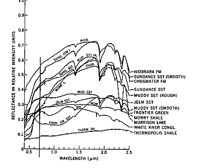
A common way of mapping formation distribution is to rely on training sites at locations within the photo/image. The identities of the rocks there are ascertained either by consulting maps appropriate to the area or by visiting specific sites in the field. Their appearance photographically or their spectral properties are then extrapolated across the photo/image to locate the units in the areas beyond the site (in effect, the supervised classification approach).
In doing geologic mapping from imagery, one must keep in mind that the formations are not necessarily exposed everywhere - they may be covered with soil or vegetation. In drawing a map, the geologist learns to extrapolate surface exposures underneath covered areas, making logical deductions as to which hidden units are likely to occur below the surface. In working with imagery alone, this may prove difficult and is a source of potential error. Also, rock ages are not directly determined from spectral data, so that identifying a particular formation requires some independent information (knowledge of a region's rock types and their sequence).
 extends across parts of Colorado, New Mexico, Arizona, and Utah.
The Plateau's best known natural feature, of course, is the Grand
Canyon. There, the Colorado River has cut nearly a mile deep into
horizontal rock strata of Paleozoic age. These horizontally layered
sedimentary rocks are the hallmark of the Plateau. Over most of
the U.S. West, great forces resulting from lateral interactions
between the North American and Pacific plates and other plates
have caused strata in the upper continental crust to be folded,
faulted, and crushed into numerous mountain belts, of which the
Rocky Mountains, the Wasatch, the Pacific Coast Ranges and many
others are prime examples (this is one of the central ideas in
the great paradigm known as Plate Tectonics). However, one region
in the West - the Colorado Plateau - responded differently by
being vertically uplifted (maintaining the initial horizontal
orientation of the cover strata) rather than being compressed
laterally into deformed units.
extends across parts of Colorado, New Mexico, Arizona, and Utah.
The Plateau's best known natural feature, of course, is the Grand
Canyon. There, the Colorado River has cut nearly a mile deep into
horizontal rock strata of Paleozoic age. These horizontally layered
sedimentary rocks are the hallmark of the Plateau. Over most of
the U.S. West, great forces resulting from lateral interactions
between the North American and Pacific plates and other plates
have caused strata in the upper continental crust to be folded,
faulted, and crushed into numerous mountain belts, of which the
Rocky Mountains, the Wasatch, the Pacific Coast Ranges and many
others are prime examples (this is one of the central ideas in
the great paradigm known as Plate Tectonics). However, one region
in the West - the Colorado Plateau - responded differently by
being vertically uplifted (maintaining the initial horizontal
orientation of the cover strata) rather than being compressed
laterally into deformed units.
Code 935, Goddard Space Flight Center, NASA
Written by: Nicholas M. Short, Sr. email: nmshort@epix.net
and
Jon Robinson email: Jon.W.Robinson.1@gsfc.nasa.gov
Webmaster: Bill Dickinson Jr. email: rstwebmaster@gsti.com
Web Production: Christiane Robinson, Terri Ho and Nannette Fekete
Updated: 1999.03.15.