The next sequence of images, each briefly described, is representative of surface classes and distinctive structural features that typify the venusian landscape.
The first is characteristic of the plains regions. Here at Lakshmi Planum are several light and dark surfaces that are interpreted to be equivalent to the basalt flow types

known as pahoehoe (smooth lavas; somewhat specular surfaces) and aa (chunky lavas, better backscatterers) - counterparts to common Hawaiian lavas.
Peculiar terrain at Ovda Regio in the Aphrodite Terra is characteristic of long low mountain ridges, running NE-SW and spaced about 20 km (16 miles) apart; a dark band is a low valley.

Prominent NW-SE bright surface features, possibly some kind of parallel fracturing, cut the ridges. A better look at systematic fractures in a plains surface appears below:

These NW-SE gashes are criss-crossed by numerous small ladder-rung like fractures, which may be analogs to regularly spaced megajoints found in certain terrestrial settings.
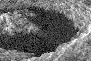
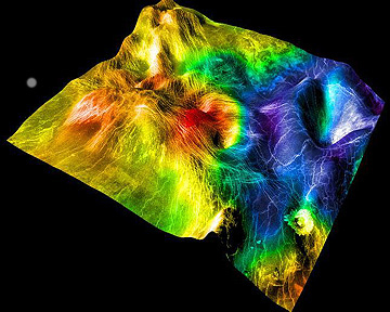
The next scene is Golubkna crater, 30 km (18.5 miles) wide, which is nearly identical to impact structures found on the Moon and Mars.
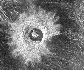
Visible are central peaks, a nest of terraces, and a wide apron of ejecta which stands out as bright because of the rough scattering surfaces. These are emphasized in this computer-generated perspective view:
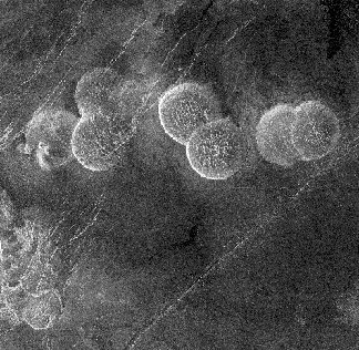
Domical hills, as much as 25 km (15.5 miles) wide and up to 750 m (2460 ft) high, dot plains in the Alpha Regio. These pancake-shaped features are believed to result from upwelling at tubular vents of lavas that spread uniformly in all directions.
Our last vertical view of the venusian surface exposes two unusual structures - given quaint names to set them apart - that seemingly develop from fracture patterns in the lava plains.

A broad weblike arrangement of linear features was dubbed "Arachnoids" by the Russians because of a resemblance to a spider's web. Smaller elliptical to circular structures known as Corona(s) (or coronae, Latin for crown) may be similar to ring dikes known on Earth.
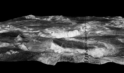
Coronas make up rimmed depressions that are evident in perspective images produced by combining the radar image with altimeter data. Two examples illustrate these and other features. The first shows broad plateaus and valleys in the Galindo region, with a corona in the foreground and a volcano-tectonic structure in the farground. Below it is a view of the Sedna Planitia region, with a corona in the landscape on the right. The colors are not altitudes but are color-coded expressions of the variations in emissivity that can be derived from the thermal data.
Because of the great diversity of surface features revealed by Magellan, Venus will remain a high priority target for space exploration well into the 21st Century.
Code 935, Goddard Space Flight Center, NASA
Written by: Nicholas M. Short, Sr. email: nmshort@epix.net
and
Jon Robinson email: Jon.W.Robinson.1@gsfc.nasa.gov
Webmaster: Bill Dickinson Jr. email: rstwebmaster@gsti.com
Web Production: Christiane Robinson, Terri Ho and Nannette Fekete
Updated: 1999.03.15.