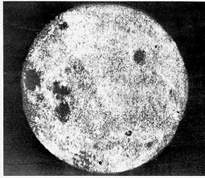
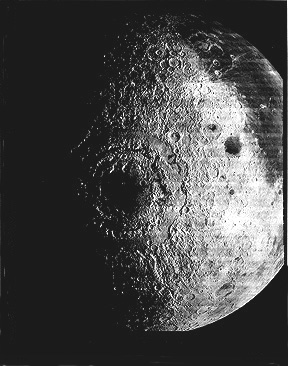
Exploration of the planets using spacecraft began with the first trip to the Moon two years after the USSR set the space program into full motion with the launch in October 1957 of Sputnik I. In September 1959 Lunik (Luna) 2 impacted onto the lunar equator. The next month Luna 3 completed the first flyby of a planetary body, returning a series of pictures of the lunar limb and a few views of much of the Moon's farside (top, below). Much better quality images of the farside were sent back from Russia's Zond 3 in their next mission during July 1965 (bottom).
The first U.S.missions to the Moon were literally a crash program! Between 1961 and 1965, three Ranger spacecraft were launched like bullets to land (impact) onto the surface, being destroyed in the process. Each Ranger had a television camera mounted in its nose that looked forward at the surface as it approached. Progressively higher resolution images were instantly telemetered back up to the moment of collision. The last was received at resolutions of just a few meters. Here is a typical example, captured by the Ranger 7 camera; each trapezoid frames the next scene in the succession:


One of the hallmarks of pre-Apollo lunar exploration was the Lunar Orbiter program in which five "photolab" spacecraft were fired into orbits around the Moon between August 1966 and August 1967 (the USSR actually was the first to orbit the Moon in April of 1966 but its image returns were minimal). The first three were inclined to the equator and the last two were in near-polar orbits. Each had a payload consisting of two cameras holding 70 mm black and white film. One camera with a wide angle lens produced photos whose resolutions ranged from 8 to 150 m (25 to 492 ft) depending on varying orbital altitudes; the second High Resolution camera improves these values by a factor of 8 but covers much smaller areas. The photos, developed onboard as negatives, consisted of continuous strips electronically scanned by a "flying spot" passed into a photomultiplier tube that generated an analog signal transmitted to Earth. Back there, the signal drives an imaging device which produces 35 mm positive strips that can be joined into mosaics. The ~2000 photos from these missions cover almost the entire lunar surface, leading to detailed geologic maps that have been interpreted mainly through superposition and cross-cutting relationships (see p. 19-5). Here are four typical scenes:

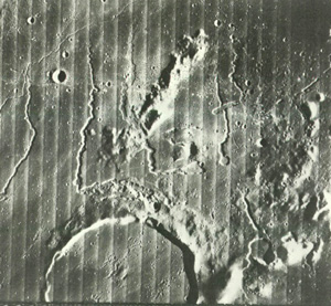
On the top is an oblique view of the Apennine Mountains, uplifted crust that is highlandslike in terrain characteristics, lapped by mare lavas from younger basalts that filled Oceanus Procellarum. Next above are lava plains with sinuous rilles (flow trenches) in Oceanus Procellarum and part of crater Prinz; each strip in the mosaic is 4 km (6.4 miles) wide.

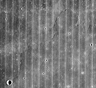
The third photo shows mare ridges (squeeze-ups) and another rille. The photo at the bottom seemingly is a bland view of a flat mare surface except that a close look discloses an upper flow unit that is marked by a distinct front that creates a lobe marking the advance; this clearly signifies basin-filling by multiple extrusions.
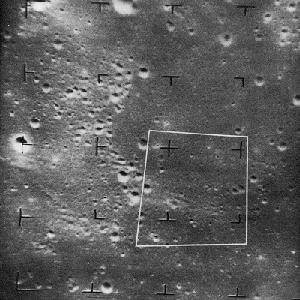
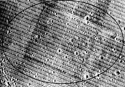
A primary goal for the Orbiters was high resolution photos of candidate landing sites. The scene below (5 by 8 km; 3 to 5 miles) documents an elliptical site in Oceanus Procellarum, near the Apollo 12 touchdown point, considered acceptable despite a seemingly high crater density.
Constructed from photo strips acquired by Lunar Orbiter IV at an average altitude of 2700 km (1677 miles), the next classic image shows the great lunar "bullseye" known as the Orientale Basin, a multiringed (perhaps 4; outermost with diameter of 900 km [560 miles)) impact structure invaded by lavas (Mare Orientale). This feature lies just beyond the visible western limb of the Moon; the western Oceanus Procellarum is at upper right.
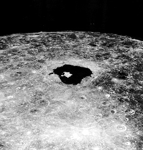
The Orbiters confirmed that cratering is a dominant process. But, signs of volcanism were ubiquitous: some volcanic calderas were identified, lunar rilles were either flow channels or collapsed lava tubes, domes were evident, and the floors of many large impact craters contain clear indications of volcanism, as in this Orbiter V view of the interior of Tycho, which shows on a larger scale many features similar to those on terrestrial caldera floors:

Code 935, Goddard Space Flight Center, NASA
Written by: Nicholas M. Short, Sr. email: nmshort@epix.net
and
Jon Robinson email: Jon.W.Robinson.1@gsfc.nasa.gov
Webmaster: Bill Dickinson Jr. email: rstwebmaster@gsti.com
Web Production: Christiane Robinson, Terri Ho and Nannette Fekete
Updated: 1999.03.15.