The outer Galilean moons also consist of exterior ice (probably commingled with some rock) atop an interior containing a rocky core and perhaps overlying liquid water or slush. Some scientists have speculated on the presence of a sub-ice ocean beneath Ganymede's icy crust that might harbor organic molecules and even simple life forms. The surfaces of these satellites are best shown in contrasty black and white images. Ganymede, third out at 1,070,000 km (66450 miles), is the largest (5263 km [3268 miles]) satellite in the solar system (larger than the planet Mercury). Ganymede has been effectively imaged by Galileo, as shown in this scene:

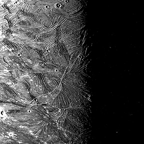
The full view highlights the two dominant terrains, seen better in this close-up:

Both terrains have been judged to be old (ancient) based on crater densities. The dark terrain occurs in patches, some with straight sharp boundaries abruptly against the other type - lighter-toned terrain with ridges and grooves. The darker terrain appears older and may have been part of a crust that after breaking apart was invaded and at times surrounded by the younger material. Each terrain seems to consist of ice, with the dark possibly foundering in later mobilized water-ice. The grooved terrain presumably was tectonically stressed to produce parallel ridges (terrestrial sea ice can develop similar but less pronounced structures). Further breakups cause smaller polygons to be wedged in a sometimes jumbled patchwork.
A high resolution Galileo image (right) of grooved terrain is compared below with a Voyager 2 image of the same area (left), proving dramatically the value of improved viewing capabilities that inevitably ensue as sensors get better and spacecraft pass closer to their targets.
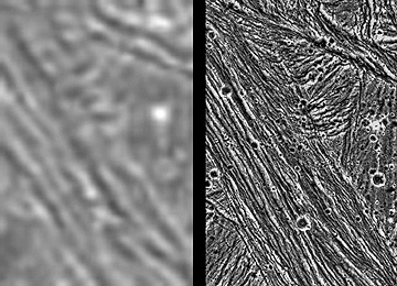
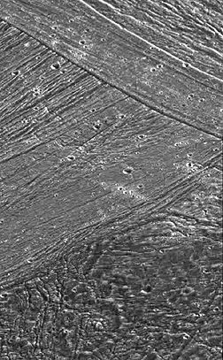
The difference resulting from 75 m (246 ft) resolution (right) versus approximately 1.3 km (8073 ft) for the left image is obvious. This type of terrain, in which grooved surfaces make up a patchwork of juxtaposed individual segments each in sharp contrast to its neighbors, is depicted again in the next sequence of three images, the last taken in July of 1998 during Galileo's last, and closest, approach:

The craters on Ganymede, as well as those on Callisto, the last of the Galilean four, differ from those on, say, the Moon in that nearly all lack raised rims and central peaks. For larger craters this should be conspicuous but these impact effects are almost completely obliterated by the effects of gravity in causing these features to collapse or slump down as the ice responds by viscous flow that evens out the higher sections of the structures. A notable exception are the pair of craters seen in an image collected during the July, 1998 close approach. These show broad raised rims - and in fact the forms resemble splash boundaries of short-lived craters produced by an object thrust into water - and dark floors which may be material carried up from bedrock below any ocean water beneath the ice.
Callisto (4800 km [2981 miles] diameter; 1,883,000 km [1,169, 343 miles] from Jupiter's center) is dominated by a single terrain made up of darker materials (possibly like the dark terrain of Ganymede). Seen in full as a photomosaic made from nine Voyager 1 images, this satellite appears to be pockmarked by thousands of lighter spots, which are impact scars in the icy surface:
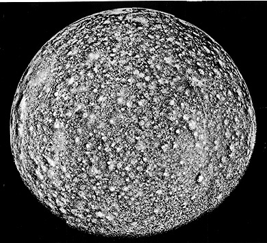
Note the details in the upper view below. Occasionally, there are strings of close-spaced craters in a long row, as seen in the lower scene.


Such an arrangement is likely due to the breakup of an incoming bolide or projectile that bombards the surface in a succession of pieces, perhaps similar to the now famous 1994 sequence of collisions on Jupiter's surface by strung-out fragments of the Comet Shoemaker-Levy, about which we will comment near the end of this Section.
Our last look at Callisto shows the great series of concentric ice rings at Valhalla Basin:
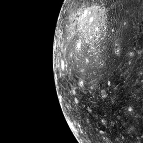
This multiringed structure has counterparts in the Caloris Basin of Mercury and Mare Orientale on the Moon. The rings are formed during or shortly after the collision that scoops out the central basin. They are crudely analogous to multiple rings in water after a stone has been cast into a lake or pond. The rings in ice tend to be "frozen" in place as formed. Over time, these topographic rims, and those of larger craters, tend to diminish in height owing to flow of ice outward from the rise.
Even as this Section was undergoing review and revision, JPL scientists have just announced that the Galileo probe has detected organic molecules on both Ganymede and Callisto. Details as to types or species are not available.
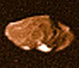
Typical of the smaller satellites is Amalthea (150 x 270 km [93 x 167 miles], whose irregular shape is shown here:
Quoting from a December 1997 JPL Press release:
The key findings of Galileo's primary mission include:
The existence of a magnetic field from Jupiter's largest moon, Ganymede.
The discovery of volcanic ice flows and melting or "rafting" of ice on the surface that support the presence of liquid oceans underneath at some point in Europa's history.
The observation of water vapor, lightning, and aurora on Jupiter.
The discovery of an atmosphere of hydrogen and carbon dioxide on the moon, Callisto.
The presence of metallic cores in Io, Europa, and Ganymede (but not Callisto).
Evidence of very hot volcanic activity on Io and observations of dramatic changes compared to previous observations.
Code 935, Goddard Space Flight Center, NASA
Written by: Nicholas M. Short, Sr. email: nmshort@epix.net
and
Jon Robinson email: Jon.W.Robinson.1@gsfc.nasa.gov
Webmaster: Bill Dickinson Jr. email: rstwebmaster@gsti.com
Web Production: Christiane Robinson, Terri Ho and Nannette Fekete
Updated: 1999.03.15.