One of the big surprises were infrequent but distinctive sinuous channels whose morphology is much more like river channels that lava channels. One interpretation holds this to be evidence of sufficient water in the past, in lakes, groundwater or possibly oceans, to have initiated some sort of hydrologic cycle involving rain storms and runoff. Most water has since evaporated into space, although small quantities may remain frozen as underground ice. Nevertheless, significant water activity has repeatedly recurred as evidenced by the types of dendritic channelling shown in these Viking Orbiter image mosaics:
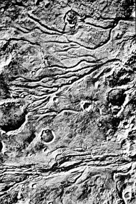
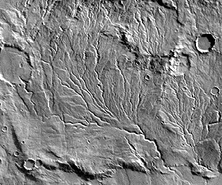
The region depicted in the top image covers the Juvenae Chasma and Vedra Vallis. These are runoff channels, a type confined to the ancient landscapes. Stream flow is the favored origin, largely by comparison with terrestrial counterparts, but multiple lava flows are a possibility. Some channels seem to originate at craters, which could imply that either water or lava were released from subterranean sources following impact offloading. The drainage pattern in the bottom image bears close resemblance to terrestrial patterns found in soft sediments or wind deposits.
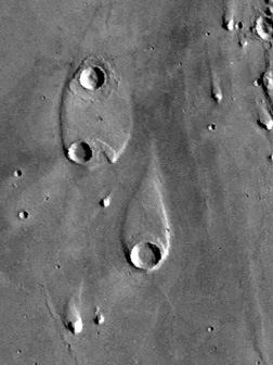
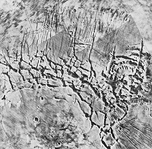
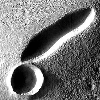
A second type of drainage has been termed outflow channelling. The channels typically are broad and deep, creating canyonlike depressions. This type of landform may have been associated with catastrophic scouring during abrupt flooding; a similar example on Earth is the Channeled Scablands of central Washington State in the U.S. that resulted in just a few weeks from rapid emptying after a natural breakup of a huge dammed lake. Outflow features commonly occur juxtaposed to chaotic terrain (top image; note the large outflow channel in the middle), in which surface units are broken up into jumbled blocks and huge slabs, left behind after subsurface waters escape leading to loss of support (a process called sapping). A teardrop-shaped landform in Elysium Planitia (bottom image) is considered a prime example of shaping by streamlining (analogous to aerodynamic sculpturing) in which water flowing from bottom to top has eroded plains material around the rim of a large crater and has terraced and perhaps redeposited debris towards the pointed end.

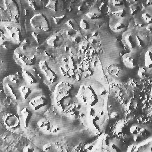
The martian surface is amazingly varied, with landforms of diverse genesis - some probably related to water action, others to tectonic forces, volcanism, and wind - being given descriptive names. Here are four examples:
One landform (above), called fractured terrain appears to be an
erosional feature imposed on joints or similar structural controls.

The mishmash of intersecting linear features, called grooved terrain
, in this case may be a complex surface of eroded
ash deposits or possibly joint enlargement of a (now buried remnant)
of a volcanic lava unit.

In the third image is an example of polygonal
terrain, which resembles on a huge scale fractures found on lava
lake surfaces or patterned ground associated with ice wedging
in periglacial regions (areas adjacent to ice sheets).
The last photo shows fretted terrain, found usually near cratered terrain, consisting of separated higher mesalike units bounded by scarps and set within lower smooth plains; this may represent incomplete dissection of older landforms by water and/or wind.
Other landform types given distinctive names (examples not shown; see map near top of page 19-12) include: furrowed terrain, knobby terrain, channeled terrain, etched terrain, and layered terrain.
The importance of those landforms with fluvial signs is that they speak to the probability that water did exist in sufficient volume and concentration in the Mars past to be available as an essential ingredient for and accessible to the inception of organic molecules. Carbon, the other vital constituent, was certainly present as indicated by today's atmosphere. Whether these elements were released from the interior or added by meteoritic matter during the accretion phase or later is still uncertain. Absence of any viable organics in samples analyzed at the Viking sites does not disprove the possibility of biogenic forms in modern Mars (they may simply not have been encountered there but dwell elsewhere) but both sites were in younger terrains - the nonoccurrence could mean that any earlier life or unorganized organic matter had perished by then.
The sensation in the scientific world during 1996 was the claim that a martian meteorite contains (disputed) evidence of life. Twelve meteorites recovered on Earth, mainly from the Antarctic, are generally accepted as having been tossed from Mars by impacts into Earth-crossing orbits. These form a group known as the SNG meteorites (consisting of the Shergotty, Nakhlite, and Chassignite types). One, known as the Allan Hills meteorite (top), has several features interpreted as consistent with organic

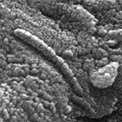
structures found in some ancient terrestrial rocks. This fragmental rock contains dark materials, thought to be old martian crust, that date at 4.5 billion years. Golden-orange carbonate globules, dated at ~3.6 b.y., are considered evidence of a primitive ocean. Associated with the globules are small amounts of polycyclic aromatic hydrocarbons that, while not necessarily biogenic, are demonstrated to be indigenous to Mars rather than contamination. Fossil-like bodies consisting of iron oxides (magnetite) and iron sulphides are present but even more lifelike in appearance is the elongate chain of tapering cylinders seen in the image (bottom, above). Needless to say, many skeptics have argued that this evidence is not persuasive - some similar features found in Earth rocks have proved to be inorganic. A recent report now claims that these tiny forms are indeed primitive bacteria but very similar to types still thriving on Earth - the implication is that this is just terrestrial contamination.
However, the possibility that they are genuine remains: if life is certified on Mars, the Earth would no longer retain its unique status as the living center of the Universe - although it is a huge leap from microscopic primitive organisms to the intelligence that can then understand them. Suffice to comment that these meteorite "life forms" are being touted as a pressing reason to formulate and accelerate a major space effort to return to Mars for more detailed exploration.
And, after a 20 year hiatus in Mars exploration, the quest for onsite information about our Red neighbor has resumed. First up was a launch in 1993 of Mars Observer, a $billion dollar spacecraft which regretably failed enroute. This was followed on November 7,1996 with the launch directed by JPL of the Mars Global Surveyor spacecraft that arrived for orbital insertion on September 12, 1997. In December of 1996 the Pathfinder mission was underway to land (successfully) a roving vehicle capable of viewing the local terrain and making sophisticated measurements. An orbiting spacecraft whose task is mainly climatic measurements has been launched in mid-December of 1998.
From an initial orbital altitude of 400 km (250 miles), the Global Surveyor will use the aerobraking technique, which involves progressive slowing through friction (drag) with the thin atmosphere, until after 6 months the spacecraft is lowered to 110 km (68 miles). From there, using thrusters to maintain this altitude, a mapping mission began in late-March of 1998 to last a minimum of 687 Earth days. A second lowering is planned for 1999.
The Global Surveyor mounts a wide- and narrow-angle camera system, the Mars Orbiter Laser Altimeter, a Thermal Emission Spectrometer to measure atmospheric heat and surface composition, a Magnetometer/Electron Reflectometer, and two other instruments. Among the first surface images, taken from the higher altitude in early October of 1997, are these two examples of the many views to be acquired during the mission.
![]()
![]()
The Mars Orbiter Camera (MOC) can take pictures with resolutions of 3 meters. (This resolution will improve slightly over time as the orbital height lessens owing to the "aerobraking" effect.) The next view, taken after the orbit had been lowered to the altitude chosen for the first major scientific measurements, shows details of the terrain surrounding an elongate volcanic caldera 2 km in length in the Tempe-Marcotis Fossae region. Almost touching it is a round crater that may be impact in origin.
The Laser Altimeter yields profiles that show martian relief. Probably the most dramatic of this presents an exaggerated profile across Olympus Mons and Arsia Mons/Alba Patera. These volcanic landforms
rise to heights above 15 km (10 miles) indicating differences in elevation that exceed any found on Earth.

One of the most exciting and informative scenes taken by the Global Surveyor combines a color view of the North Pole Ice Cap with topographic data obtained from a series of Laser Altimeter passes to produce this three-dimensional view:

The size and amount of ice (which was confirmed by the spectrometer to be largely water ice) was less than anticipated from pre-Surveyor observations. The cap is roughly 1200 km (750 miles) in dimension (crudely circular) and as much as 3 km (1.8 miles) thick. With an average thickness of 1 km (0.62 miles), the volume of ice amounts to about 1.2 million cubic kilometers (300,000 cubic miles), roughly half that of the Greenland Ice Cap on Earth. The cap's general surface is quite smooth but the Ice Cap is cut by large, deep (up to 1 km; 3000 feet) steep walled canyons and troughs whose origin appears to be enlargement of cracks by wind and possibly meltwater. The amount of water thus locked up at the North Pole, and lesser quantities now at the South Pole, does not seem sufficient to have once made an ocean over parts of Mars; it instead may today be the remnants of much of any seawater that could have existed in the Mars past. Relationship of this surviving water to the riverlike channels on Mars is still speculative. Water may be widespread even now on Mars but would be subsurface. Detection of that water is one of the objectives of future Mars missions.
The Thermal Emission Spectrometer is capable of identifying some individual minerals and determining in a semi-quantitative way
their proportions in the surface rocks (believed to be primarily basalt and andesites). The mineral Pyroxene (an iron-magnesium
silicate) occurs in rocks found in Syrtis Major. Note its variable distribution, with the largest amounts present in the darker
areas of this region.

Launched on December 4, 1996, JPL's Pathfinder landed on July 4, 1997 in the Ares Valle near the earlier Viking 1 site . This shorter transit time results from the closer proximity of Mars to Earth just a month later together owing to a different orbital configuration. The primary scientific purpose of Pathfinder was the release shortly thereafter of the small Sojourner Rover, guided from Earth through the lander's communications system, that moves independently (after departing down a ramp from the lander) to distances up to 20 meters on its six flexible rocker wheels to nearby sites of interest to image them and to bring its spectrometer up against a rock surface for analysis.
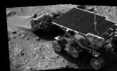
This microrover, which weighs 11.5 kgm (25.4 lbs), measures L = 630 mm (24.5 in), W = 480 mm (18.7 in), and H = 280 mm (10.9 in). Using power from a solar panel, Sojourner can move at a maximum speed of 40 mm/min during the martial day. Its front and back wheels can be each be moved independently to control its steering. The microrover has a stereo camera mounted at its front which fixes on objects in its path as they are approached. The journey is in intermittent steps, as operators on Earth determine changes in direction needed to reach target rocks or avoid threatening obstacles. This takes extended time periods owing to the long distances radio and video signals must travel back and forth. If small rocks are encountered, the wheels can raise up to glide over the obstruction.
Images of the surface around the lander are obtained by a stereo camera system, with color filters, on board the lander as well as from Sojourner's camera (mainly rock close-ups). A panoramic montage of most of the surrounding site, in which rocks that were visited are named (using friendly words that speak a personal touch), is shown here.
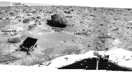
Many of the rocks are grayish on fresher surfaces. These surfaces
may be weathered and pitted, and often are at least partly dust-covered.
A typical large rock is Yogi, which appears to have a reddish
dust blanket on one side and a sharp boundary with fresher rock
(right side).

The primary instrument on the microrover is the APXS, or alpha-proton-x-ray spectrometer. This instrument uses high speed alpha particles to bombard soil or rock surfaces. This generates a back scattering of alpha particles, alpha-proton particles, and x-rays whose energies as determined at the detectors are indicative of a wide numberof elements. Elements such as those in rocks, i.e., Si, Al, Ca, Fe, Mg, K, Na, Ti, Mn, Cl, S, P, O, and C can be thus detected quantitatively. These can be reported in elemental form or as oxides. The diagram below is a plot in histogram form of many of these elements from Barnacle Bill, Scooby Doo, Yogi and soil sites. Barnacle Bill's composition is close to that determined earlier at the Viking site but the other rocks and soils are different.

The next graph (left, below) is a plot of values of elemental ratios of Fe/Si and Ca/Si from the Pathfinder site compared with certain Earth rocks. The martian rocks are definitely not basalt in composition. They plot close to but not within the compositional field of the terrestrial volcanic rocks known as Andesites. When the elemental composition of the Pathfinder rocks is recalculated into what petrologists term normative rock compositions, it is seen that the mineralogy is similar to andesites (right).
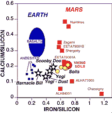
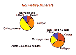
But the presence of normative quartz (leftover silica, after all other SiO2 is assigned to the other oxides, technically makes this rock type a dacite. Both andesites and dacites are the common volcanic rocks emitted from continental volcanoes such as those along the Ring of Fire (e.g., the Pacific Coast Cascades). Presence of these rock types at this martian site, if typical of much of Mars, suggests that the Red Planet had melted and differentiated so that at least part of its crust is andesitic. Paul Lowman (author of Section 12 of this Tutorial) had postulated more than a decade ago that an andesitic primordial crust probably developed early in Earth history and may be the norm for other inner planets.
Compositional data have now been gathered at three widely separated martian sites (the other two are the Vikings). In general, the sites all are similar in their chemical makeup. This may simply mean that the martian crust is homogeneous but even more likely is the explanation that martian wind circulation has scattered and homogenized compositional differences across the planet. The distribution of rocks and boulders at the Pathfinder site further supports earlier ideas that at one time in the martian past there was considerable water cover and resultant flow currents giving rise to a pattern sometimes observed on Earth as flood-related.
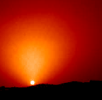
The last Pathfinder image we show below is a classic sunset picture, taken through the thin dusty martian atmosphere that produced a fan-shaped glow around the now smaller Sun.
We mention again only in passing the third of the '90s Mars missions, Surveyor 98, scheduled for launch on December 11, 1998 to eventually orbit Mars at an altitude of 400 km (250 miles). Its Orbiter will concentrate mainly on gathering climatic data. A Lander will detach to set down near the South Pole to search for water.
It has been known since 1877 that Mars has two small satellites - Phobos (mean diameter = 21 km; [13 miles]) and Deimos (17 km [10.6 miles]). Mariner 9 captured the first detailed views of these tiny bodies. Their irregular shapes are similar to asteroids that have been imaged by radar and their dark surfaces are suggestive of the carbonaceous chondrite matter thought to comprise these bodies; these insinuate that the martian satellites are captured strays from the asteroidal belt that extends between Mars and Jupiter. Here is a view of Phobos:
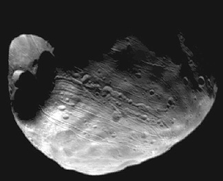
Small craters dot its surface but one large one, named Stickney, came close to disrupting it. This cratering is consistent with the likelihood of collisions with smaller objects during a period of residence in the asteroid belt. The grooves may relate to this crater.
Mars, the outermost of the terrestrial planets, remains an exciting and diverse place to visit (perhaps by man) in the foreseeable future. NASA, and much of the scientific world, continues to promote the idea of an eventual Mars manned mission sometime after the year 2010. In the meantime, several more orbiters, probes, and landers will seek out additional critical information to support such a venture. The International Space Station now under construction, and scheduled for completion in 2002, would be a favorable launch pad for Man's great adventure to the Red Planet.
Code 935, Goddard Space Flight Center, NASA
Written by: Nicholas M. Short, Sr. email: nmshort@epix.net
and
Jon Robinson email: Jon.W.Robinson.1@gsfc.nasa.gov
Webmaster: Bill Dickinson Jr. email: rstwebmaster@gsti.com
Web Production: Christiane Robinson, Terri Ho and Nannette Fekete
Updated: 1999.03.15.