
The Chicxulub impact into shallow waters of the Gulf of Mexico generated huge waves and, even more destructive to the Earth, tossed enormous amounts of rock and water into the atmosphere. This in turn caused a worldwide "cloud deck" of aerosols, gases and particulates leading to temperature fluctuations and diminution of photosynthesis that wiped out much of the food chain and provided the "coup de grace" to the few dinosaur families still living then on Earth. The resulting debris ejected into high altitudes was transported around the globe to settle out as a thin layer of deposits (containing iridium, a metallic element present in some meteorites, and mineral grains bearing evidence of intense shock [see below]) that marks the precise K/T boundary between the last rocks of the Cretaceous (symbol K) Period and the first sediments formed in the younger (overlying) Tertiary Period (symbol T).
As you might guess, younger, usually less eroded craters are recognized
by their morphology or external form. They are approximately circular
(unless later distorted by regional deformation), have raised
rims, show structural displacements in their wall rocks, may have
a central peak consisting of rocks brought up from deep original
positions. The morphology of such craters can be emphasized in
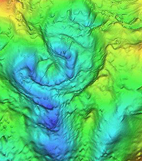
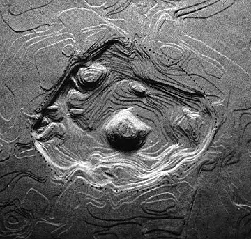
3-D perspectives (commonly using DEM data) of their contours,
exaggerating the elevations and applying shading or artificial
illumination (computer-controlled). Two examples illustrate how
craters that today have moderated and often low relief can be
made visually more obvious. On the top is the Flynn Creek structure
(3.5 km; 2.2 mile wide) in Tennessee; on the bottom is the 24
km (15 mile) wide Ries Kessel in Bavaria:

In general, craters smaller than 3-5 km in diameter lack central peaks, i.e, they have bowl-shaped interiors, and are termed simple. Most larger craters have central peaks in which the rock below the true crater boundary have "rebounded" upward from the collision, further aided by centripetal forces associated with crater wall slumping; these are called complex craters but erosion and infill may subdue the peaks. Flynn Creek, like most other craters in the U.S. cut into carbonate rocks, just barely received a central peak still expressed topographically; the Ries does not retain a morphological peak but depth to the crater boundary as determined by drilling is less in the interior.
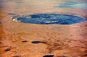
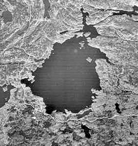
Simple craters (and some larger ones) often have depressions that
are filled by water. On the top below is the 3.5 km (2.2 mile)
wide New Quebec crater in granitic shield rock exposed in Northern
Quebec. On the bottom is the much older West Hawk Lake structure
(2.5 km; 1.6 mile diameter) formed in metamorphic rocks in easternmost
Manitoba (first studied in detail by the writer [NMS]).


In Canada, and other northern latitude countries, these lakes freeze over in winter, allowing support for drill rigs that explore the crater infill materials by recovering core.
Most younger craters are surrounded by deposits of fragmental
rock. An example (top, below) of such rock (termed breccias) from
an outcrop at the Ries crater illustrates these ejecta deposits.
A second example (bottom) seen in core from drilling that penetrated
the Manson central peak shows the diverse nature of the several
rock types making up these breccia fragments (called clasts).
Eroded craters lack definitive external shapes, although the initial
circularity may have a persistent effect on drainage, keeping
streams in roughly circular courses. Such craters are often hard
to detect but presence of anomalous structural deformation and
of brecciated rocks afford clues. In rocks that were just outside
the original wall boundaries, a peculiar configuration known as
shatter cones commonly develops.
These "striated" conical structures (described as "horsetail"-like in shape) can be very small or can reach 6 feet or more in length, as seen above in quartzites at the Sudbury, Canada impact structure (as an aside: the writer's "favorite" geological outcrop anywhere is the low bank partly around the parking lot of the MacDonalds fast food restaurant in downtown Sudbury, where this continuous cluster of shatter cones was exposed during excavation). When folded rocks containing the cones are restored to their original positions on a spatial plot, the cone apices invariably point toward an interior location that lies above the central crater floor - in effect, denoting the position where the energy source was released from above, a situation incompatible with a deep volcanic source as once advocated by skeptics. The cones, which also sometimes form in rocks subjected to nuclear explosions, occur in lower (peripheral) shock pressure zones as shock waves spreading outward place the rock into tensional stress; many cones appear to originate from point discontinuities (e.g., a pebble) as though the waves were diffracted.
Code 935, Goddard Space Flight Center, NASA
Written by: Nicholas M. Short, Sr. email: nmshort@epix.net
and
Jon Robinson email: Jon.W.Robinson.1@gsfc.nasa.gov
Webmaster: Bill Dickinson Jr. email: rstwebmaster@gsti.com
Web Production: Christiane Robinson, Terri Ho and Nannette Fekete
Updated: 1999.03.15.