As you would suspect, there are many examples of primarily scientific studies using remote sensing that embrace most of the disciplines already considered in this Tutorial. Section 14 on Meteorology is a cogent illustration of a field within the Earth sciences that has both a strong research scientific bent and a broad set of applications, some being direct spin-offs from satellite programs that were initially proof-of-concept efforts. Because of the professional background of the writer (NMS) as a geologist, there seems an overabundance of examples in this field - resulting in part from the obvious fact that geologic phenomena often dominate the imagery created by remote sensors. In keeping with this experience, Basic Science II again draws upon a subject of dominant geologic nature that also was once a specialty of the writer - namely, impact cratering. When he was active in that subfield, it was considered esoteric. Now, 30 years later impacts are "hot" topics, especially since they were "fingered" as a cause of dinosaur extinction. More to the point, both scientists and the general public have come to realize that impacts are genuine dangers to mankind, capable of causing catastrophes greater than any other natural process known to affect the Earth's surface, and are likely to occur (as they already have) as huge events some time(s) in the future of civilization. This subject of impacts is both pertinent and interesting - and impact craters are often detectable by remote sensing - so read on!
One of the payoffs of the space program is the realization that
collisions of fast-moving asteroids, comets and large meteorites
onto growing or stable planets are one of the predominant processes
acting during their formative period. Moreover, ongoing impacts
persist in modifying such bodies throughout their subsequent history.
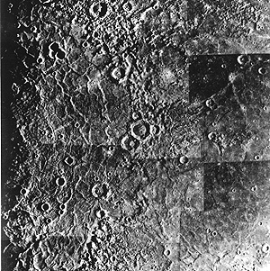
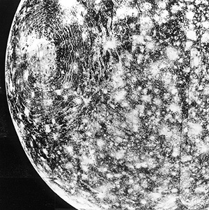
The surfaces of some terrestrial-type planets and many of their
satellites display a profusion of craters that totally pockmark
their surfaces: Mercury (top) and Callisto (fourth satellite out
from Jupiter) are prime examples.
Earth's Moon is conspicuously cratered with generally circular
depressions ranging in size from less than an inch to more than
1200 km (800 miles) in diameter; you can easily spot many of the
larger ones at full Moon through a pair of binoculars. The most
conspicuous lunar impact structure is Tycho (left) located on
the Moon's southern hemisphere. It is readily picked out as the
source of great streaks (rays) almost visible to the naked eye
that result from deposits of ejecta hurled across the Moon.
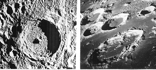
This crater is the classic exemplar of a large impact structure, with these hallmarks: circular raised rim; concentric nest of slumped walls inside this rim; central (uplift) peak; rough, irregular crater floor (here a mix of fragmental ejecta and lava extrusion); exterior ejecta in hummocky deposits. Typical of farside craters is Goclenius (55 km; 34 miles wide) and several smaller ones (right) as they appeared to Apollo 8 astronauts circling our lunar neighbor. Note their flat interiors filled with mare lavas.
Less than 100 years ago the concept of craters being formed by impacts from meteorites and other extraterrestrial bodies ("bolides") such as comets was considered unrealistic and highly improbable. Several scientists had by then suggested that the Moon was covered with such craters but the bulk opinion attributed these to volcanic processes. The proposal that Meteor Crater in Arizona had an impact origin, conceived by G.K. Gilbert and then supported by finding iron meteorites around it, followed with the classic study of cratering mechanics there by Eugene M. Shoemaker, opened up the possibility of impact as the cause of similar circular features. Gradually, the idea that impact is one of the fundamental formative processes acting on planets won broad acceptance. In fact, it is now proven that planets grow by accretion of infalling materials, with the craters representing the last stages of buildup as the planets reach their full sizes. The nature of impact cratering is of such importance - yet is still poorly treated in introductory geology textbooks - that the writer (NMS) has drawn upon his experience in this field to prepare this summary.
Heavily cratered planetary bodies, such as the above, share in common ancient surfaces that have not been fully demolished or masked by erosion, lava outflow, deposition, or obliterating mountain activity. Cratering on their surfaces was most intense from the last stages of planetary growth, very early in solar system time (beginning about 4.6 billion years ago), through a later period of about 1 billion years after which the flux of objects striking those surfaces dropped off notably. Earth, Venus, and parts of Mars, also profusely cratered at the outset, by contrast now show far fewer craters owing to subsequent destructive processes that erased or covered most of the impact evidence left on the primitive surfaces.
Earth today, despite its many recyclings of continental and oceanic crust, retains signs of huge impacts imposed in the last two billion years as well as smaller ones that took place even into historic times. About 160 surviving craters of definite or probable impact origin have already been found on our planet. This is much below the estimates of tens of thousands that would be expected if Earth's surface and crust had not experienced such dynamic ruin from plate tectonic action and atmospheric-driven erosion. Also, protection by deep oceanic waters (more than 70% of the planet is so covered) and burial by sediments further account for this deficiency in anticipated numbers. Nevertheless, more craters remain to be discovered - satellite imagery should be an effective means for conducting a systematic search, as we shall see near the end of this survey.
The world map below that locates nearly all known craters on Earth's
land surfaces was extracted from the Home Page of a Web Site on
Terrestrial Impact Cratering (http://gdcinfo.agg.emr.ca/crater/world_craters.html) put together by the Geological Survey of Canada (GSC). The distribution
of craters seems non-uniform, a fact explained by variations in
ages of surficial rocks, distribution of mountain systems, and
differences in extent of exploration.
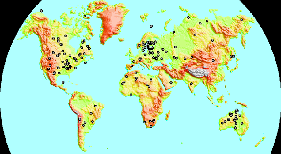
The map is also displayable by individual continent after accessing this site; for each continent, the craters are named and these can be clicked on for a description and, often, an aerial view, along with their precise geographic coordinates, size, and estimated time of formation. The same group at GSC has also put online an extended narrative (http://gdcinfo.agg.emr.ca/crater/paper/cratering_e.html) that discusses crater formation and morphology, identification, and possible hazards in the future, which will nicely supplement our review in this subsection. A similar treatment, supported by selected images of terrestrial and planetary craters, has been prepared by Calvin Hamilton at (http://bang.lanl.gov/solarsyst/tercrate.htm).
For those seeking a comprehensive and technical treatment of crater mechanics, we recommend the book Impact Cratering: A Geologic Process by H.J. Melosh, 1989, Oxford Monographs on Geology and Geophysics No. 11, Oxford University Press.
Code 935, Goddard Space Flight Center, NASA
Written by: Nicholas M. Short, Sr. email: nmshort@epix.net
and
Jon Robinson email: Jon.W.Robinson.1@gsfc.nasa.gov
Webmaster: Bill Dickinson Jr. email: rstwebmaster@gsti.com
Web Production: Christiane Robinson, Terri Ho and Nannette Fekete
Updated: 1999.03.15.