You have already encountered some exceptional examples of tectonic landforms in Sections 2, 6, 7 and 9, which you can review (look particularly at the Zagros folds and the Pindus thrust belts in Section 2 and the Appalachian folds and Basin and Range block fault mountains in Section 6). These zeroed in on folds and faults, the most common types of tectonic deformation. The resulting landforms are commonly emphasized by differences in elevation (relief) that may be sufficient to change ecosystems developed at these heights. Thus, mountains in a semi-arid climate may be heavily vegetated (dark toned in visible band images) and adjacent basins less so (light), affording strong contrasts in black and white images (the Nimbus 3 image in Section 14 is a good example). Mountainous terrains are also highlighted in Landsat type and radar images by virtue of shadowing which causes tonal variations related to slope/sun positions.
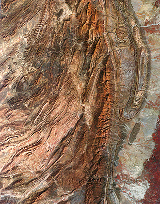
Since you have already seen several examples of fold belts, we
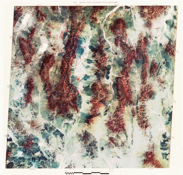
will only re-enforce this survey with one additional image, here
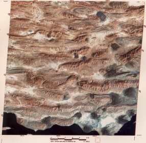
in western Pakistan showing part of the fold belt that was the
consequence of the huge collision between the Indian subcontinent
and southern Asia (the context of this is evident in the mosaic examined earlier in section 7). The scene shows the Sulaiman
fold belt consisting of en echelon (offset) anticlines (some closed)
making up the ridges (flat valleys occupy intervening synclines).
The Kingri fault passes through the image center (look for an abrupt
discontinuity); the crustal block to its west (left) has moved
northward relative to the block on the east.
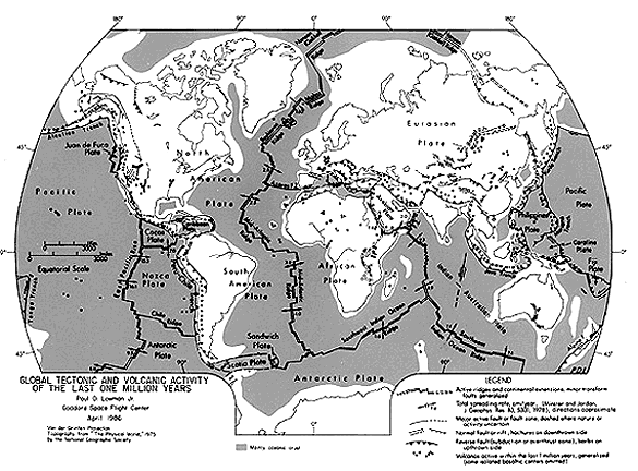
To the west is the Arabian tectonic plate, caught between the
African, Eurasian, and Indian-Australian plates as they move in
different directions. The western part of this plate is a crystalline
shield (a continental nucleus containing ancient igneous and metamorphic
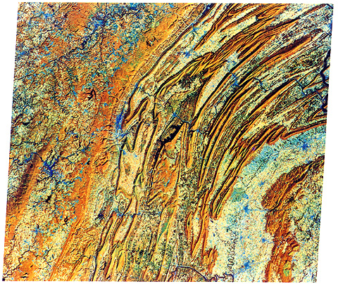
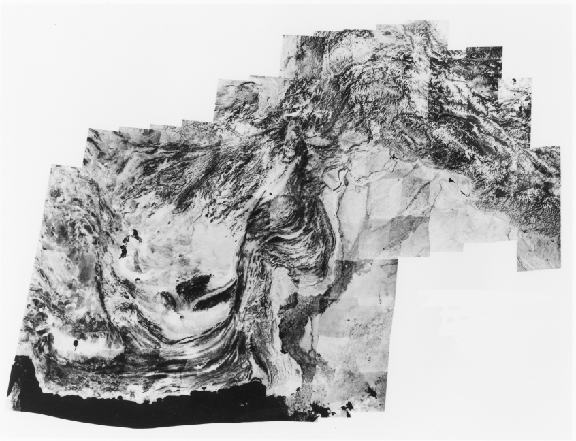
rocks). Below is a mosaic (from 12 individual Landsat scenes)
of the shield as exposed in southern Saudi Arabia and the Yemen
Arab Republic.
A dominant feature in this scene is the numerous granitic intrusions whose boundaries show as distorted oval shapes. The shield is a region of low mountains separated by valleys, many of which are sand-covered. A prominent escarpment (first seen near upper left edge) bounds the western edge of the shield. The coastal plain itself is edged by a fault-controlled scarp. Another scarp (lower right) is also fault-related.
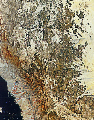
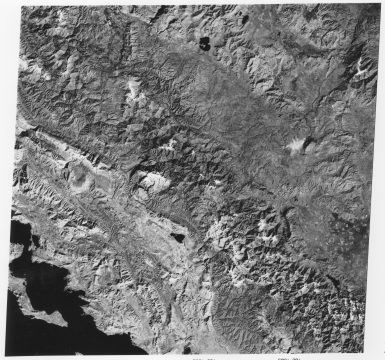
Another remarkable mosaic covers much of northwestern Australia,
a region of limited vegetation so that the rocks and valley fill
stand out and reveal much of their underlying structure. This
is the Western Australian shield, containing mostly Precambrian
metasedimentary and metavolcanic rocks, interlaced in places by
igneous rocks. At the top of the mosaic is the Pilbara block,
the writer's leading candidate for the classic expression of an
ancient greenstone-granite complex anywhere on Earth.

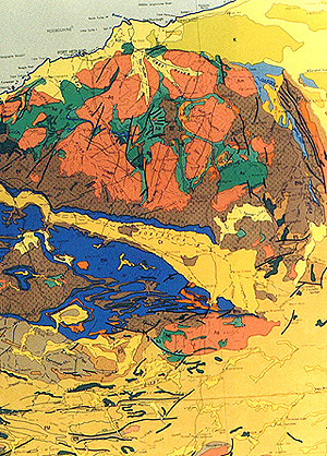
The granite is exposed as batholiths up to a 100 kms (62 miles) in length; these light rocks are diapiric intrusions into the dark greenstones (metamorphosed basalt). To the south is the Hamersley Range (blue area on map) and the smaller Opthalmia Range (red), bordered on the south by the Ashburton Trough (left) and the Bangemall basin (right). Much of the region is marked by hills of low relief; the highest area (1235 m; 4013 ft) is in the Hamersley Range.
Turning now to volcanic landforms, we show two images that represent
two major types of volcanoes.
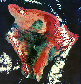
On the top is the Big Island of Hawaii (see Sections 8 and 14 for other renditions). Mauna Loa, whose summit crater, a collapse caldera named Mokuaweoweo, lies beneath a crest at 4135 m (13,438 ft), is the central part of a huge shield volcano which comprises the entire island; its base lies about 4000 m (13000 ft) below sealevel, in sum making the entire edifice the tallest single mountain in the world (Everest, while higher, rises from the valleys of the Himalayas that are thousands of meters above sealevel, so its relief is less). Numerous lava flows (dark basalt), many extruded over the last few centuries, emanate from Mauna Loa. Mauna Kea, a crater on the north section of the island, is now extinct. But the most active volcano in the world, Kilauea, lies along the east side of the island; it is visible here as a dark patch. This island is quite young, consisting of multiple layers of basaltic flows built up in the last one million years. Hawaii is the latest in a series of volcanic islands formed from melted lower crustal rocks as the Pacific plate moves northwestward over a fixed hot spot in the Earth's mantle; a newer submarine volcanic complex now forming southeast of Hawaii will eventually surface and replace the Big Island as the center of activity.

Above is a segment of Java, the main island in the Indonesian archipelago, a prime example of an island arc terrane still in process of evolution. Midst thick sequences of geosynclinal sediments are a series of large composite stratovolcanoes developed from crustal melt induced by frictional heat as the Indian-Australian plate dives in subduction below the southernmost extension of the Eurasian plate (see tectonic map at top of this page). The stratocone on the north peninsula near the Java Sea is Muria. The highest (2910 m; 9460 ft) volcano is the active Merapi, which stands out as the lower of two in the left center. To its right is Lawu; six other large volcanoes are mainly to the west (left) of Merapi.
Code 935, Goddard Space Flight Center, NASA
Written by: Nicholas M. Short, Sr. email: nmshort@epix.net
and
Jon Robinson email: Jon.W.Robinson.1@gsfc.nasa.gov
Webmaster: Bill Dickinson Jr. email: rstwebmaster@gsti.com
Web Production: Christiane Robinson, Terri Ho and Nannette Fekete
Updated: 1999.03.15.