Earlier, we introduced the idea of ridge density (defined as total
length of ridges per unit area). A regional map of ridges was
produced from the 1:250,000 topographic sheet from which densities
were calculated using a digital program. This list shows that
densities vary by a factor of two among the major terranes in
the Klamaths:
| TERRANE | RIDGE DENSITY |
| ELK 1 (Ki) | 5.41 |
| ELK 2 (Ki) | 4.91 |
| YOLLA BOLLY (KJD) | 4.35 |
| ROGUE VALLEY (JRV) | 4.10 |
| DRY BUTTE (JDB) | 3.98 |
| PICKETT PEAK (JC) | 3.46 |
| SIXES RIVER (KJS) | 3.29 |
| SMITH RIVER (JJ) | 3.03 |
| SNOW CAMP (KJM) | 2.70 |
This density value is related to several factors, chief being the "fineness" of the drainage network.
From this map the orientations of ridges (normalized to lengths)
for the entire region can be plotted:
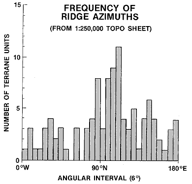
Then, using the above-mentioned program in which the ridges are entered as data points on a digital plotting board that converts them to lines whose average trend directions can be calculated, the orientations of the ridges for any chosen area (such as a terrane or fraction thereof) can be plotted in rose diagrams like those shown above for the Elk and Sixes Rivers terranes. Below is a map in which the most common orientation interval (in 5° units) is drawn in red and the second most common in blue. The prevailing direction for terranes including and east of the Yolla Bolly terrane is NNE, in keeping with the regional plot just shown. But, in the Elk and Sixes River terranes that direction becomes NW.
What might account for this shift in trends? This next (and last)
diagram is a speculation:
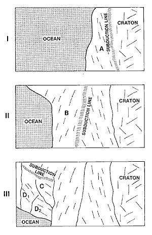
In upper panel I, a new terrane smashes into the continental craton along a subduction line of given geometry (including orientation). As the terrane is pushed under (or, it can override the continent), it takes on a fabric whose principal direction(s) is governed by the stress field imposed during emplacement. Now, in panel II, the subduction zone location and geometry have changed and a somewhat different fabric orientation results. In panel III a new subduction zone (bounded by a transform fault [not shown]) adopts a notably shifted orientation and this is passed on to the docking terrane. Then, as erosive processes gradually carve out topographic expressions for the terrane assemblage, streams whose paths tend to be controlled by underlying structural fabric produce valleys and intervening divides that reveal the effects of the stress fields by preferred orientations.
The bottom line: Remote Sensing at present has a limited but positive role in the analysis of landforms by virtue of its excellence in creating synoptic images that highlight regional relationships interpretable visually. This role will increase significantly as high resolution stereo becomes commonplace on sensors flown in space. Ultimately, this will lead to the topological expression of surfaces in a quantitative mode that will prove its worth again, as it has from aerial photography, as a prime approach to geomorphic characterization.
Code 935, Goddard Space Flight Center, NASA
Written by: Nicholas M. Short, Sr. email: nmshort@epix.net
and
Jon Robinson email: Jon.W.Robinson.1@gsfc.nasa.gov
Webmaster: Bill Dickinson Jr. email: rstwebmaster@gsti.com
Web Production: Christiane Robinson, Terri Ho and Nannette Fekete
Updated: 1999.03.15.