In the interests of both science and economics, addressing the scientific questions often requires that several instruments--each addressing a different but related issue--are designed to work with each other. This suite of instruments is then mounted on a spacecraft that is launched into Earth orbit. The size of the spacecraft and its design are, in turn, dictated by the instrument complement to be flown (with their own requirements, as outlined above), the size of available launch vehicles, etc. The Earth Observing Satellite (EOS) series meet these specifications (get more details on this and the rest of the EOS-AM program at http://eos-am.gsfc.nasa.gov/).
An example of a state-of-the-art instrument being built for the
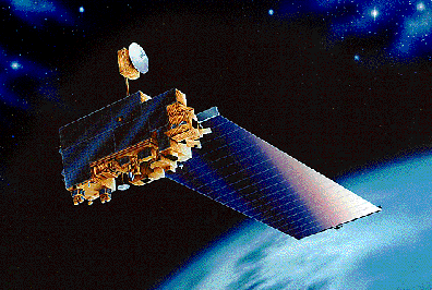
first EOS flight (EOS-AM, to be launched in June 1998) is the Moderate
Resolution Imaging Spectroradiometer, or MODIS. MODIS is designed
to measure biological and physical processes on a global basis
every one to two days. The instrument will provide long-term observations
from which to derive an enhanced understanding of global dynamics
and processes occurring on the surface of the Earth and in the
lower atmosphere. The MODIS instrument employs a conventional
imaging radiometer concept, consisting of a cross-track scan mirror
and collecting optics, and a set of linear detector arrays with
spectral interference filters located in four focal planes. The
optical arrangement will provide imagery in 36 discrete bands
(hyperspectral mode) selected for diagnostic significance in Earth
science. The spectral bands will have spatial resolutions of 250m,
500m, or 1km at nadir (the point directly below the instrument
as it orbits the Earth). The instrument's data rates range from
6.2 Mbps (average) to 10.6 Mbps (day) to 3.2 Mbps (night). It
is temperature-controlled by radiative cooling. The instrument masses 225 kg,
has a 100% duty cycle, requires 175 W (average) and 225 W (peak)
power. In its stowed (launch) configuration, its dimensions are
about 95 x 158 x 134 cm.
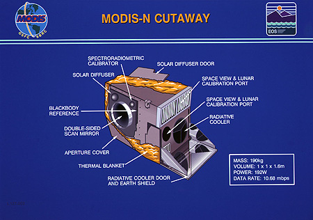
To ensure that measurements provided by the instrument are both precise and accurate, a complex series of on-board calibrators is being provided. As the instruments scan mirror makes a revolution, these calibrators provide information on a per-scan basis that will serve to place the measurements being taken in a trustworthy framework.
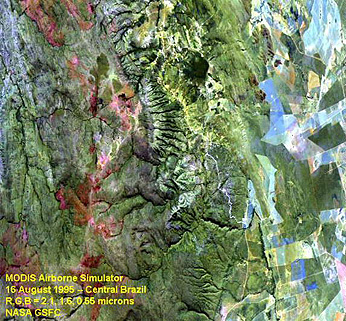
Here is an example of a characteristic 3-band color composite made with the MODIS Airborne Simulator (MAS) sensor using selected MODIS bands, showing a scene in Central Brazil taken in August of 1995.
In the case of the first EOS flight, known as AM-1 because of its designated morning equator-crossing time, MODIS will be joined by four other instruments, two of them being provided by some of the program's International Partners:
Of special interest in this battery of instruments is ASTER , shown here.
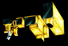
A combination of wide-bandwidth coverage, high-resolution mapping, and stereo DEM is unique to ASTER; it is designed to operate in tandem with MODIS. A radiometer in the VNIR consists of 3 bands (between 0.52 and 0.86 µm (15 m spatial resolution; a second radiometer uses six bands in the SWIR region between 1.6 and 2.43 µm (30 m resolution); the TIR (thermal emission) radiometer will have 5 bands between 8.3 - 11.3 µm (90 m resolution). There is also a separate single band at 0.76-0.86 µm inclined backward at 27.6Á from nadir that will provide along-track imagery capable of being used stereoscopically with one of the VNIR bands to permit images to be displayed in the DEM (Digital Elevation Model) mode. The VNIR bands are directed towards measuring snow, water, vegetation, and degree of oxidation of the land surface. The SWIR bands are optimized for mineral identification, especially hydrated minerals in clay-rich soils. The TIR bands seek to identify major rock types and also to fix land-surface temperatures.
Each instrument being built for EOS will be characterized first by mathematical (computer-based) models that will allow scientists and engineers to determine its response to operating conditions. In addition, as each data-collecting measurement is based on an algorithm--a set of mathematical and operational instructions--a detailed analysis of that algorithm is provided in an Algorithm Theoretical Basis Document (ATBD). The ATBD presents the scientific and physical basis for the measurement, and documents how that basis is translated into computer code that will convert the physical measurement into data products that will give the geophysical parameters required to answer the questions being asked.
Designed to have an orbital lifetime of at least six years, EOS AM-1 will provide data on clouds, aerosols, and radiative balance; will allow characterization of the terrestrial surface; and will provide data on the global carbon cycle.
As complex as a satellite such as EOS AM-1 can be, it has neither the proper instrument complement nor the longevity to handle many of the other issues addressed by MTPE and related programs. How, then, do we acquire all the needed data?
EOS has been designed as a multi-year mission, with as many as
18 different orbit-based components similar in concept (if not
in detail) to AM-1. By designing many such spacecraft based on
the guidelines outlined above, a mission profile is formulated,
one that, over time, will provide the necessary data. The EOS
Mission Profile is presented here:
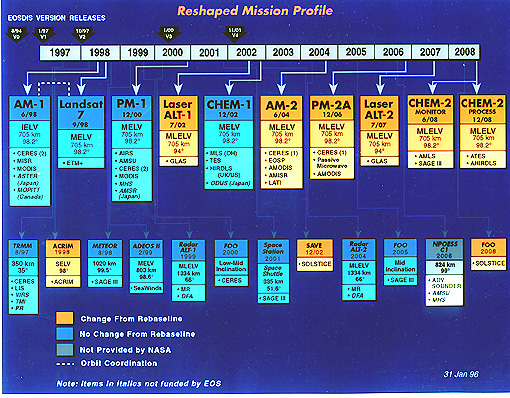
To allow for flexibility in the mission, not all instruments have been assigned to specific flights. There are several places where an instrument is to be flown an a "flight of opportunity," or "FOO." While this profile extends only to 2006, the full suite of instruments and flights continue beyond 2006 to provide a full 15-year-long data set, as required by scientific drivers to the program, as described above.
Landsat-7 is scheduled for launch in July of 1998, approximately 1 month after the launch of EOS-AM. It will act both independently and in synergistic support of EOS, and is now considered an integral part of the MPTE program. Landsat-7 mounts only one sensor, the ETM+ (or Enhanced Thematic Mapper) that has identical spectral wavelength coverage as earlier TMs (with the same 30 m resolution except that the thermal band is improved to 60 m). It will also have (the +) a panchromatic (0.5-0.9 micrometers) band with 15 m resolution. The special feature of Landsat-7 will be its launch and orbit parameters which will allow the space vehicle to trail (follow) the EOS-AM platform (within its swath) by 15-30 minutes each day. Observations from both systems can thus be integrated, and atmospheric data from EOS sensors can be used to correct for effects of water vapor and temperature on Landsat image characteristics.
Code 935, Goddard Space Flight Center, NASA
Written by: Nicholas M. Short, Sr. email: nmshort@epix.net
and
Jon Robinson email: Jon.W.Robinson.1@gsfc.nasa.gov
Webmaster: Bill Dickinson Jr. email: rstwebmaster@gsti.com
Web Production: Christiane Robinson, Terri Ho and Nannette Fekete
Updated: 1999.03.15.