GIS has been defined by the Association for Geographic Information
as:
A system for capturing, storing, checking, integrating, manipulating, analyzing, and displaying data which are spatially referenced to the Earth.
A simpler working definition: A computer-based approach to interpreting maps and images and applying them to problem-solving.
The role of GIS in the general planning process for site selection,
environmental managing, and other geographically-dependent applications
is synopsized in this diagram:
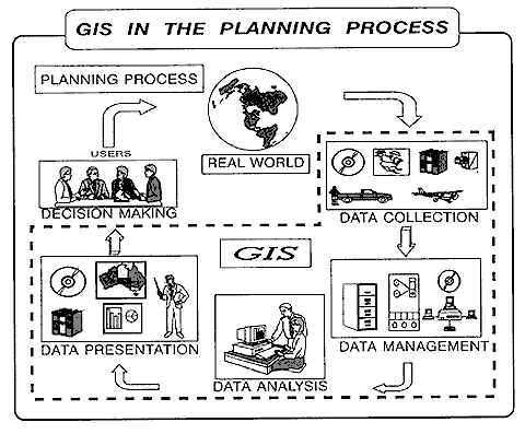
From B. Davis, GIS: A Visual Approach, ©1996. Reproduced by permission of Onword Press, Santa Fe, NM.
The driver for this closed-loop operation is the constant need
for timely information about human activities and expectations
concerning life in the "real world". The specifics underlying
those needs define the types and amounts of data/information required.
Once stipulated, the data are collected from multiformed sources,
such as already published maps and tabulations, current field
observations, surveys, and aerial/satellite imagery. The next
step involves conversion of varied data into computer-compatible
formats. The heart of the GIS operation lies within various techniques
for analysis that have been devised with the evolution of GIS
itself. Reports, displays, new maps, statistics and other kinds
of computer-based information-oriented products are then presented
as output to the decision-makers for judicious utilization. The
test of value is then conducted by application of the results
in the same real world that dictated initial requirements. Data
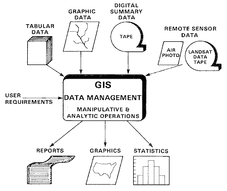
management through a GIS involves all of these facets:
Code 935, Goddard Space Flight Center, NASA
Written by: Nicholas M. Short, Sr. email: nmshort@epix.net
and
Jon Robinson email: Jon.W.Robinson.1@gsfc.nasa.gov
Webmaster: Bill Dickinson Jr. email: rstwebmaster@gsti.com
Web Production: Christiane Robinson, Terri Ho and Nannette Fekete
Updated: 1999.03.15.