Atmospheric Sounders
There is another class of sensors that performs valuable data
gathering about the atmosphere in a three-dimensional mode to
various depths. These are the sounders, which can look vertically
through atmospheric levels or look off-nadir through longer pathways,
particularly through the atmospheric limbs nearly tangent to the
Earth's surface. Among many such instruments, we can mention as
typical: HRIS - the High Resolution Infrared Sounder (20 channels
from the visible to 15 micrometers; resolution is actually coarse
at 42 km); the SSU (Stratospheric Sounder Unit); MSU (Microwave
Sounder Unit); VISSR (Visible Infrared Spin-Scan Radiometer),
a 2-channel sounder on GOES, which also may have the GOES 1-M
sounder; the SBUV-2 (Solar Backscatter UltraViolet) radiometer;
LIMS (the Limb Infrared Monitor of the Stratosphere); and SAGE
(Stratospheric Aerosol and Gas Experiment). Sounders are especially
suited to obtaining temperature, water vapor, ozone, and other
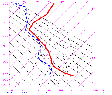
trace-gas data that can be plotted in profiles. Here is a (somewhat
degraded) example of temperature (red) and water vapor (blue)
profiles over Denver, Colorado on January 13, 1997 as calculated
from the GOES-8 Sounder.
However, because satellites sweep over much of the Earth, particularly
those in near-polar orbits (see below), and thus take data readings
continuously with position change, the sounding data can be presented
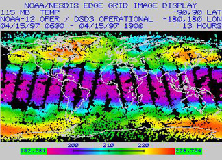
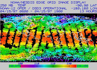
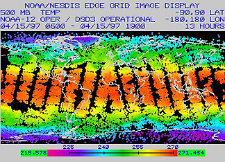
as global maps. As an example, consider these maps of global temperatures
at four different altitudes (specified as pressures in millibars)
as determined by the TIROS Operational Vertical Sounder (TOVS)
on Nimbus 12 on April 15, 1997 (115 mbars is approximately at
15 km; 950 mbars is near the surface):
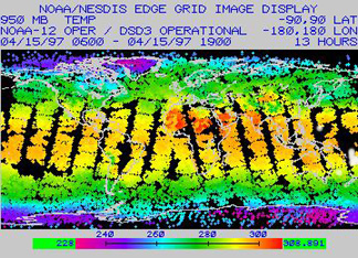
A number of similar maps made from atmospheric sounder instruments on metsats will be displayed elsewhere in this section.
We can only scratch the surface (really, the atmosphere) on this subject of instrumentation that operates on metsats. For example, the Nimbus series actually supported 24 different experimental systems, involving a variety of sensors. The interested user should consult Kidder and Vonder Haar.
Classes of Metsats
Meteorological satellites fall into two general classes in terms
of their orbital characteristics. Most can be grouped into the
POES or Polar Orbiting Environmental Satellite category. These
are launched into orbits at high inclinations to the Earth's rotation
(at low angles with longitudes) such that they pass across high
latitudes near the poles. Depending on orbital altitudes, angular
velocities, and inclinations, these satellites can be sun-synchronous,
that is, they in effect move in their descending mode about 11°
westward (as the Earth rotates underneath) with each complete
trip around the world being of such duration (about 105 minutes
long) that they cross some reference position (e.g., the equator)
at the same local time. This time is usually between mid-morning
and mid-afternoon on the sunlight side of the orbit. Thus their
swaths are imaged at about the same sun time during each pass
so that lighting remains roughly uniform (of course the clouds
have changed with each orbit but their broad patterns and positions
are retained in the short periods involved so that a daily mosaic
made from the swaths is a good general summary of global weather
patterns for that period). This same orbital configuration applies
to Landsat, SPOT, and some of the other land observers. Other
POES members have inclinations or other orbital constraints such
that they will cross equivalent latitudes at different times of
day, allowing observations over various times in the diurnal cycle.
Most POES orbits are circular to slightly elliptical at distances
ranging from 700 to 1700 km (440 - 1050 miles) from the geoid;
at different altitudes they must travel at different velocities.
The second type of metsat is in the GOES (Geostationary Operational Environmental Satellite) class. These are geosynchronous in that the rotational velocity of a given satellite at some altitude closely matches that of the angular velocity of a point on the Earth beneath. This altitude can vary (so that the satellite velocity must be adjusted) between about 35000 and 41000 km (22300 and 25460 miles) but is typically set near 6.6 Earth radii. At a 35000 km distance, the orbital velocity must be ~11000 km/hr (6830 mph) to keep pace with an equatorial point velocity of ~1673 km/hr (1038 mph). Parked usually very close to the equator at nadir, and orbiting parallel to it, the result is that the satellite is also geostationary (fixed) relative to that equatorial point so that it observes the Earth without any significant relative motion). At this distance, and with a wide FOV, the Earth appears as a full disk (but the area covered is less than a hemisphere, being about 1/4th of the planetary surface). Both the Earth and the satellite, in synchronization, rotate relative to the Sun so that part of each day the satellite's sensors will be facing the night side. But, because of the night effect, to view the Earth in daylight continuously requires at least three (preferably four) geostationary satellites located in different positions around the globe. Under these orbital conditions, the sensors can look at the disk at any moment, gaining a synoptic image in which all meteorological elements are viewed synoptically in real time. Visible images typically are aquired 30 minutes apart and infrared images at a lower frequency. GOES platforms are usually paired, being spaced about 75° apart; current GOES units above the western hemisphere are referred to as GOES-East and GOES-West.
Some of the above information will be expanded upon later in this
Section. Its content will be built around four objectives: 1)
the historical development of metsat programs; 2) examples of
the kinds of data/information, as rendered in images and maps,
supplied by these systems; 3) emphasis on the global nature of
many of the observations; and 4) consideration of oceanographic
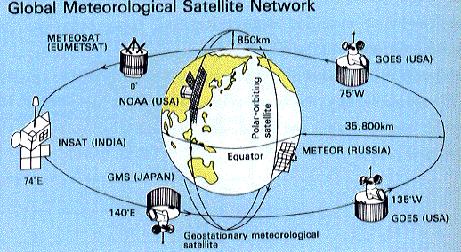
and land hydrologic investigations. This next figure offers a
quick look at most of the major metsat systems now operating to
provide worldwide or hemispherical coverage.
Code 935, Goddard Space Flight Center, NASA
Written by: Nicholas M. Short, Sr. email: nmshort@epix.net
and
Jon Robinson email: Jon.W.Robinson.1@gsfc.nasa.gov
Webmaster: Bill Dickinson Jr. email: rstwebmaster@gsti.com
Web Production: Christiane Robinson, Terri Ho and Nannette Fekete
Updated: 1999.03.15.