Here is a general Site operated by the National Oceanographic and Atmospheric Administration (NOAA) to give you a quick overview: http://www.ncdc.noaa.gov/. Click on Search NCDC. You can enter any appropriate term or key word(s) in the Search Box. A good opening choice: Meteorological Satellites. Try also the Site maintained by USAToday, at http://www.usatoday.com/weather/wfront.htm. Three in that site to click on are: The Basics; TopicsIndex; and Forecasting. Some instruction is also given on a Site produced at the University of Illinois, at http://covis.atmos.uiuc.edu/guide/guide.html. For a comprehensive, but general, review of U.S. meteorological satellites, check into this Site maintained by Florida State University: http://www.met.fsu.edu/explores/Guide. By exploring these Sites, and others they point to, you should gain a fair familiarity with "what's out there" in the world of weather and climate. Unfortunately, less is available online that instructs in oceanography or hydrology. Try entering those key terms in your Internet Search Box. For now, lets pick up a few basic principles and concepts underpinning satellite meteorology.
The chief tool for conducting meteorological observations is still any sensor that images in the Visible spectrum. The target of interest is primarily clouds - their types, distribution, extent, rates and directions of movements, and potential for rainfall. Clouds and other components of weather systems - the atmosphere, and the oceans - are also well-suited to sensing in various regions of the Infrared. Water and gases have distinct absorption bands in these regions as well as characteristic emissions. Generally, when an infrared sensor is mentioned regarding metsats, it refers to the thermal infrared region of the spectrum, particularly in the interval from 10 - 14 micrometers but also the 3 - 5 micrometer region. In those segments of the EM spectrum clouds are cooler than the land and usually water as well. If imaged conventionally, clouds would appear dark, contrary to one's experience. The image is customarily inverted (photographically when printed, or simply by numerical transformation of the digital data to make low values large and high smaller prior to printing or display) to produce images with clouds as the whitist features in the scene.
For nearly 20 years now, the "workhorse" imaging sensor on many
metsats has been the AVHRR (Advanced Very High Resolution Radiometer).
AVHRR has five channels, whose characteristics are:
| Band Number | Wavelengths (µm) | Main Uses |
| 1 | 0.58-0.68 | Day clouds; snow; ice |
| 2 | 0.725-1.10 | Surface water; snow; ice |
| 3 | 3.55-3.93 | Fires; clouds at night |
| 4 | 10.30-11.30 | Day/nite cloud & surface temperatures and mapping |
| 5 | 11.50-12.50 | Same as 4; water vapor |
AVHRR has flown on NOAA polar-orbiting satellites starting with TIROS-N, and is still very much used today (GOES series).
The ground resolution at nadir for this instrument, for a field
of view of 1.4 milliradians (producing a swath width of 2400 km [1490
miles]), when flown at 830 km (515 miles) is 1100 meters (3600
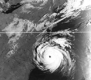
ft). Without further ado, we preview a typical AVHRR product,
a NOAA-6 view in the visible of Hurricane Diana off the U.S. East
Coast on September 12, 1984 - hurricanes generally are the most
photogenic of the large weather systems, as we shall see again.
In general, metsats do not require the higher resolutions of land satellites since their principal targets are large assemblages of clouds; the highest resolution system, at 600 m (1970 ft) are sensors onboard DMSP (Defense Meteorological Satellite Program) spacecraft. The tradeoff is to couple the sensor(s) to an optical telescope with large fields of view (FOV) that allow wide swathwidth or full disk coverage depending on orbital parameters. The successive swaths can be joined to produce timely mosaics - covering large regions or most of the Earth over a 24-hour cycle. (Therein lies a big difference between metsats and landsats in that the former seek clouds while the latter are neutralized by them unless they happen to be the targets of interest [Landsat, SPOT and others produce excellent subregional cloud pictures suited to mesoscale analysis].)
Other imaging sensors in active use on U.S. metsats (several will be detailed later in the Section, together with descriptions of some now obsolete sensors; sensors on foreign satellites will not be reviewed except for brief mention of pertinent characteristics when images made by them are introduced) include the two-channel OLS (Operational Line Scanner) on DMSP satellites,the 6-channel CZCS (Coastal Zone Color Scanner) on Nimbus-7, and TOMS (Total Ozone Mapping Spectrometer) on several recent satellites. HCMM (see Section 9) provided useful visible and thermal imagery of clouds. ERBS (Earth Radiation Budget Satellite) measures both incident and reflected, and longwave, radiation to fix the energy budget related to solar insolation and outgoing re-radiation (with a terrestrial component). Both active radar and passive microwave sensors also operate on some metsats. They can be particularly effective in detecting and tracking several forms of precipitation, such as rain droplets. Radars on Seasat and the SIR series (flown on Shuttles) are used specifically for oceanographic studies. Nimbus 5 and 6 carried ESMR (Electrically Scanning Microwave Radiometer) and 7 included SMMR (Scanning Multichannel Microwave Radiometer). The SSM/I (Special Sensor Microwave Imager) operates on DMSP satellites. Japanese, Canadian, and European satellites also mount radar or microwave systems which look at both water and land targets.
Code 935, Goddard Space Flight Center, NASA
Written by: Nicholas M. Short, Sr. email: nmshort@epix.net
and
Jon Robinson email: Jon.W.Robinson.1@gsfc.nasa.gov
Webmaster: Bill Dickinson Jr. email: rstwebmaster@gsti.com
Web Production: Christiane Robinson, Terri Ho and Nannette Fekete
Updated: 1999.03.15.