Beginning in the 1980s, a revolution in remote sensing began to come on line
with the development at the Jet Propulsion Laboratory by Dr. Alexander F.H.
Goetz and his colleagues of a powerful new instrument called AVIRIS (for Airborne
Visible-Infra Red Imaging Spectrometer).* This instrument took advantage
of new detector technology to permit the extension of ground-based spectrometers
into the air on moving platforms. Thus, the distinct value of obtaining hyperspectral
curves - essentially continuous spectral plots that measure reflectances from
the ground, water, or the atmosphere in the wavelength region responding to
solar illumination (Visible-NearIR-Shortwave IR) on which also are recorded
the fine-details of absorption phenomena - has opened up the possibility of
acquiring detailed data on the materials and classes present on the Earth's
(or other planets) surfaces, so that rigorous analysis of their compositions
over large areas is now feasible. Moreover, the data can be displayed either
as spectral curves with detail similar to those on the preceding page, thus
capturing the valuable information associated with diagnostic absorption troughs,
or as actual images similar to those obtained by Landsat, SPOT, etc. but constructed
from variations in reflectance covering very narrow bands (e.g., 0.01 micrometers),
yielding relatively "pure" scenes colorized (through color compositing) from
intervals that represent limited color ranges in the visible or in false color
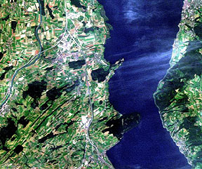
for the Near-IR (NIR). As an example, consider this pastoral scene produced
as a true color image from data obtained by another imaging spectrometer (AVIRISwiss'91).
As experience was gained in operating AVIRIS, other imaging spectrometers were built, using different spectral dispersion devices, detector size, and other variables. We shall discuss the basics of instrument design later, along with a list of many of these operational spectrometers. As a result a large number of service organizations have emerged or expanded to offer hyperspectral remote sensing as a commercial product obtainable from aircraft flights. By the turn of the millenium, imaging spectrometers will enter space (a spaceborne version of AVIRIS, known as SISEX, was once scheduled for Space Shuttle operation but was a victim of technological and budgetary constraints; a HyperSpectral Imager [HSI] was launched in 1997 onboard the Lewis satellite but that system failed to reach a functional orbit).
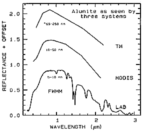
The obvious improvements in information content gained by operating a spectrometer
from air/space platforms are evident in this plot of the spectral response for the mineral Alunite
(potassium-aluminum sulphate) (MODIS is an instrument that will fly
during the EOS missions scheduled to begin in 1999; see Section 16).
Before describing these various imaging spectrometers and examining imagery and applications associated with them, we need to take a more extensive look into fundamentals of spectroscopy itself than was presented in the Introduction of this Tutorial. To do this, the next few pages will contain a condensation of a valuable review produced by a leading spectrometrist, Dr. Roger N. Clark of the U.S. Geological Survey.
* A benchmark paper at the outset of imaging spectroscopy's appearance as a
viable remote sensing tool is: Goetz, A.F.H, G. Vane, J.E. Solomon, and B.N. Rock, 1985,
Imaging Spectroscopy for Earth Remote Sensing, Science, v. 228, pp. 1147-1153
Code 935, Goddard Space Flight Center, NASA
Written by: Nicholas M. Short, Sr. email: nmshort@epix.net
and
Jon Robinson email: Jon.W.Robinson.1@gsfc.nasa.gov
Webmaster: Bill Dickinson Jr. email: rstwebmaster@gsti.com
Web Production: Christiane Robinson, Terri Ho and Nannette Fekete
Updated: 1999.03.15.