We now present a gallery of exemplar photos taken from representative Shuttle missions. Some of these are paired sideways on your screen (but, for small screens, may be displayed as top and bottom pictures). Each is preceded by brief descriptions.
Let's start with a sequence showing active and recent volcanoes on three continents. In the first pair, on the top is a vertical photo taken during STS-59 that shows a snow-covered island in Russia's Kamchatka Peninsula (far east Siberia) that is built around two volcanic calderas at each end, both with a central stratocone. Below it is an oblique scene that traces a long plume emanating from the Kliuchevskoi volcano in that peninsula during an active eruption.


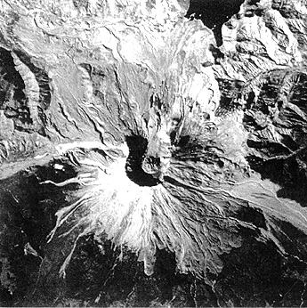
Mt. St. Helens, in southern Washington State, erupted catastrophically in 1980. It was photographed in 1994 with a Nikon 300mm lens during the STS-64 mission, clearly showing the still persistent aprons of ash deposits, despite considerable reforestation, lobes of lahars (ash-mud flows), and the great gap where part of the mountain was blown away.
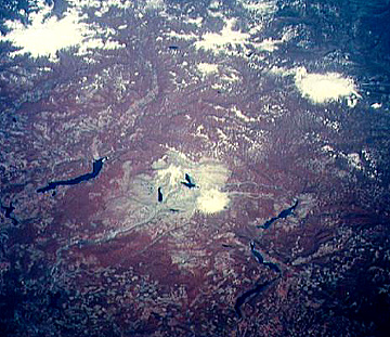
It is interesting to place this mountain in context with two other great stratovolcanoes in the Cascade Mountains of the western U.S. These two Shuttle views, one an oblique false color IR picture (looking northwest) and the second a near vertical natural color shot, show Mt. St. Helens to the west and Mounts Rainier and Adams to the east, all snow-capped. Indeed, MSH is the only volcano that is significantly offset from the main line of the Cascadian volcanic activity. Note the clear-cutting patterns in the forested countryside.
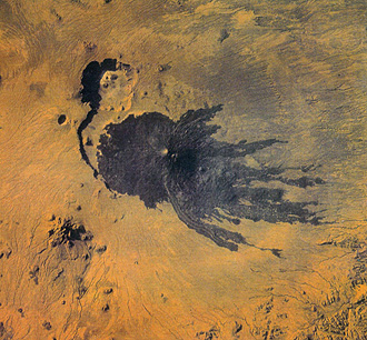
A recent volcano, known as the Pic Tousside, in the Tibesti Mountains in the Sahara of Chad (Africa), is noteworthy because of the insect-like shape created by several basalt flows:
Large areas of the global surface have been depicted by both astronaut photography and geostationary satellites. Observe, on the top, a southwest-looking STS photo of the Great Lakes in the northern U.S. and adjacent Canada. Compare this with a mosaic made from Nimbus AVHRR false color images that cover all of these lakes (state and province boundaries are superimposed). Test yourself in identifying each of the Great Lakes.


Cities are witnessed in context with their surroundings in STS pictures. On the top below is Tokyo Bay in Japan (STS-56). Tokyo itself is in the upper left; Yokohama in the lower left. On the right (east) side of the Bay are built-up areas that include large landfills bounded by retainer walls around which ship docks are positioned. Compare Tokyo's visibility with the winter scene (STS-60) of Montreal in Quebec, Canada (bottom), in which cleared streets stand out against the snowscape much like a dusted fingerprint.


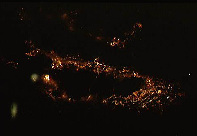
Some remarkable pictures have been taken from space in the dead of night. In one example, from the Shuttle, San Francisco Bay is outlined by the orange color made by the collective lights of cities and towns around this metropolitan region. The second, a mosaic that covers all of the U.S., highlights cities and towns across this nation in terms of bright illuminated areas imaged by the one of the Defense Meteorological Satellite Program (DMSP) satellites. (See if you can locate the region in which you live using the pattern of lights from metropolitan areas near you; what accounts for the numerous linear patterns developed over most of the composite of the U.S.; how many areas of concentrated light can you identify as urban centers?)

Finally, the Shuttle crews are always on the look-out for terrestrial phenomena around, rather than on, the Earth. Here are two views, from STS-45 and STS-47, of the aurora borealis - also known as the Northern Lights - appearing as spectacular light bands caused when electrons and other particles from the solar wind strike atoms in the outer atmosphere.

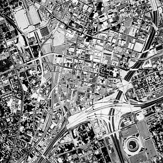
The Russian cosmonauts have also had a long-standing program for acquiring space photos. In recent years, the Kosmos KVR-1000 camera has been operating on their MIR Space Station. Pictures using this camera, available commercially, can have spatial resolutions as high as 2 meters (about 6.5 feet). An example of the sharpness achieved in such photos is this view of part of downtown Atlanta, Georgia:
The topics summarized in this Section should, first, point to the unique role of trained humans in space and, second, underscore the value of hand-held photography. A third advantage of pictures from manned missions is their low cost and ready availability compared to automated observation satellites like Landsat, SPOT, and similar space imagery, that generate both expensive and proprietary products. Fourthly, many hand-held pictures are generally well-suited to educational use because of their natural color and their obliquity, providing easily understood views of the Earth from orbital altitudes. Finally, the photography stands as a record of long-term changes (going back to the 1960s) of the Earth's surface whose appearance nevertheless as well as its physical structure are continuously changing, sometimes within minutes.
Code 935, Goddard Space Flight Center, NASA
Written by: Nicholas M. Short, Sr. email: nmshort@epix.net
and
Jon Robinson email: Jon.W.Robinson.1@gsfc.nasa.gov
Webmaster: Bill Dickinson Jr. email: rstwebmaster@gsti.com
Web Production: Christiane Robinson, Terri Ho and Nannette Fekete
Updated: 1999.03.15.