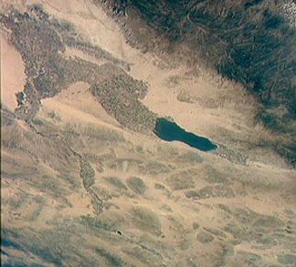
To keep things in perspective, it should be pointed out that space photography of the Earth's surface, as differentiated from weather satellites (Section 14), has been carried out since 1960 by the U.S. Air Force under the now-declassified CORONA program. Thousands of high resolution pictures had already been obtained, but these and the programs that procured them (CORONA, ARGON, and LANYARD) were highly classified then. Published in Life, the National Geographic, and many newspapers, the Gemini photographs were the first real demonstration of the scientific and applied utility of orbital photography. They are even today of archival value, because in 3 decades since they were taken in some places significant geomorphic and environmental changes have altered the appearance of the terrain. Africa's Lake Chad, for example, has visibly shrunk, as has the Aral Sea in Asia.The Gemini astronauts also conducted a wide range of astronomical and other specialized types of photography. Terrain photos often showed oceanographic features well, and were studied intensively by R.L. Stephenson and others.
The most important result of the Gemini terrain photography was its stimulus to what eventually became the Landsat program. Under the leadership of W.A. Fischer and W. Pecora, the Gemini pictures were the central evidence cited by the U.S. Geological Survey in proposing its Earth Resources Observation Satellite (EROS) in 1966. Interagency conflicts arose, but in due course EROS became ERTS, the Earth Resources Technology Satellite, later renamed Landsat. (A popular account of these developments has been published by Hall *). However, it is not generally realized that ERTS can be considered an Apollo Program "spinoff" in that the Gemini photography demonstrably was an effective catalyst that stimulated satellite remote sensing, as postulated by Lowman (1996) *. ERTS undoubtedly would have developed anyway, as an offshoot from weather satellite imaging, but it is safe to say that Gemini advanced it by perhaps 5 years.
Although of excellent quality, the Apollo 7 pictures were never subjected to detailed analysis because of the tight flight schedule involving the first lunar trip in Apollo 8.
The Apollo 8 trip, famed for its broadcast of greetings on Christmas Eve as the Moon was being circled, was something of an improvisation to test the Saturn V launch vehicle before the Lunar Module was ready for flight. Another goal was to insure that the Soviet Union's Zond spacecraft did not make the first lunar mission (see Shepard and Slayton, 1994) *. As the first manned mission ever to reach escape velocity, it had enormous impact worldwide. The hand-held 70mm photographs, including the first color pictures of the Earth rising from the limb of the Moon,
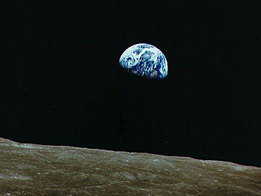
were truly historic. Scores of lunar surface photos were taken and, although coverage was sporadic compared to the pictures from the five Lunar Orbiter missions, they proved fascinating to the public and scientists alike.
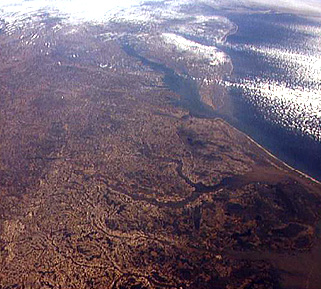
The first manned flight of the complete "stack", i.e., Saturn V with all components or stages, was the low earth orbit Apollo 9 mission. After completing tests of the Lunar Module, the crew, commanded by Col. J.A. McDivitt, acquired more than 1100 70mm color photos of the Earth using single hand-held cameras. As an example, check this shot looking up the East Coast of the U.S, with North Carolina in the foreground, the Delmarva and Delaware Peninsulas in the middle, and Long Island near the top right.
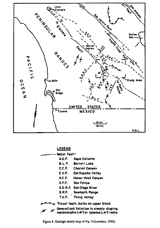
Furthermore, they carried out a film rehearsal of ERTS, employing coaxially-mounted 70mm cameras with color and black and white film to produce multispectral terrain photographs as part of the S065 experiment (Lowman, 1980) *. The montage of 4 photos that cover San Diego and the California/Mexico Peninsular Ranges includes upper left: false color infrared; upper right: green filter; lower left: red filter; lower right: black & white infrared.
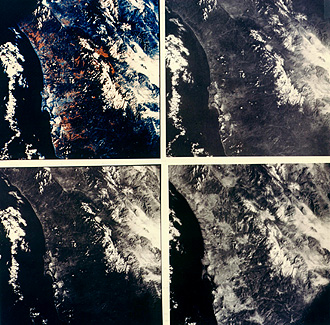
The write (PDL), in his role as a Principal Investigator in this experiment, used these pictures along with ground truth and geological map data to generate this interpretive sketch map:
The Apollo 9 mission was the most productive flown to that time, yielding superb pictures, some of which to this day have not been surpassed as records from space of certain areas. It has been suggested that Earth's atmosphere was actually clearer in 1969 than when Shuttle missions began some years later. For example, the Amazon Basin, a "blue ocean" in the words of the Gemini 9 astronauts, was by the 1990s generally obscured from smoke rising from land clearing.
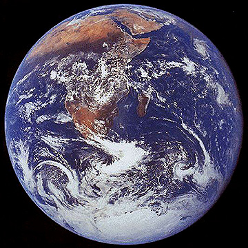
Geostationary weather satellites, Galileo, and other spacecraft have returned great pictures of the full Earth from space. But, still ranking number 1 (in request popularity) is this photo of our planet, showing Africa and surrounding oceans, taken during Apollo 17's return from the final manned mission to our lunar neighbor.
Collectively, the deep space Apollo views of Earth have been credited as a major force in stimulating the environmental movements of the 1960s and later by reminding us of the incredible isolation of this blue and white planet in the blackness of space.
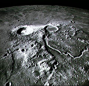
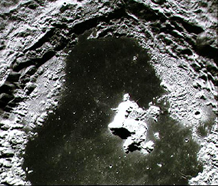
The six Apollo lunar landing missions also returned enormous numbers of photographs of Earth's satellite from lunar orbit and on the Moon's surface. A good collection of these was published by Masursky et al in 1978 *. Here are two Apollo 16 examples: an oblique photo (top) that shows the impact crater Aristarchus and a neighboring crater of probable volcanic origin, as attested by its lack of central peak and terraces and the large (Schroeter's) rille traced to it; and (bottom) a near vertical close-up of Tsiliokovsky Crater on the lunar farside.
Code 935, Goddard Space Flight Center, NASA
Written by: Nicholas M. Short, Sr. email: nmshort@epix.net
and
Jon Robinson email: Jon.W.Robinson.1@gsfc.nasa.gov
Webmaster: Bill Dickinson Jr. email: rstwebmaster@gsti.com
Web Production: Christiane Robinson, Terri Ho and Nannette Fekete
Updated: 1999.03.15.