AERIAL PHOTOGRAPHY
Most textbooks on Remote Sensing are outgrowths of earlier texts that once dwelt dominantly on acquisition and interpretation of aerial photos. These new books still include one to several chapters on this basic, convenient approach to Earth monitoring. We shall allot only limited time and space to explore some essentials of this expansive topic in the present section and the next - which considers photogrammetry as the tool for quantifying topographic mapping and other types of mensuration - but for those with deeper interests we recommend consulting the reading list in the Overview.
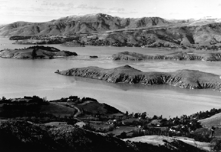
Littleton Harbor is on the South Island of New Zealand
in the foreground and a panorama with reduced detail in the background. Normally, aerial photos are vertically oriented, that is, they result from the camera pointed straight down (to the nadir, at the photo center point) to show the surface directly from above. Both the size of the photo itself and the sizes of the features represented within the photos can vary depending on the optical parameters the camera, surface area of the film exposed (frame size), subsequent printing sizes (e.g., enlargement), and altitude of the platform from which the picture is taken. The ratio of the size of any object, feature, or area within the photo to its actual size in the picture is called scale (discussed below).
We will now present a series of aerial photos acquired at different times and scales, most covering areas that lie within this June 1977 Landsat image (scale = 1,000,000 of south-central Pennsylvania, a scene we have looked at in earlier Sections.
June 1977 Landsat image centered on Harrisburg, PA
This scene contains heavily forested fold ridges (some of the bluish-black areas are defoliation patches caused by the Gypsy Moth; others near top center are surfaces covered with black dust from the Anthracite coal strip mining in fold valleys; bluish areas in the wide valleys are fields still bare or with early stage growth). It is bisected by the Susquehanna River which empties into the top of Chesapeake Bay. Near left center a blue pattern with spokes is Harrisburg, the state capital, with York below it and Lancaster to the right. A standard medium-scale (meaning moderate area of coverage but with considerable detail [individual buildings still visible]) black and white aerial photo of part of Harrisburg is shown first.
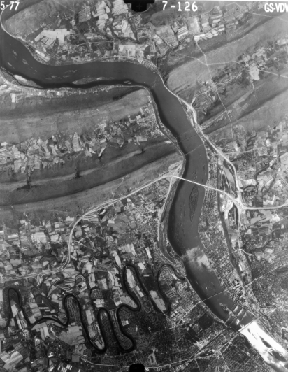
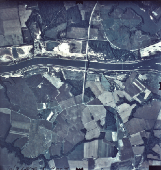
Harrisburg (Scale = 1:100,000)
The number in the upper left corner of this b & w photo of Harrisburg is the date; on the right is the Mission number; and in center is a number denoting the flight line and particular photo within that line. Individual fields, smaller rivers, bridges, and roads are easily picked out. The next photo is large scale (small coverage area; its high resolution allows features smaller than buildings [e.g., cars] to be identified) and covers an area within Harrisburg [just east of the previous photo] bisected by Interstate 83. Note particularly the lake-filled quarry (left center).
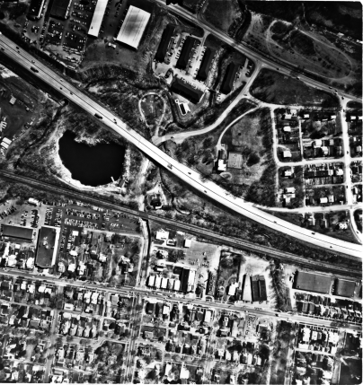
Urban Harrisburg (1:4000)
In the lower right corner of the Landsat image is an agricultural area along the Chesapeake and Delaware Canal. Its expression in a moderately large scale natural color photo is shown here:
Natural Color Photo (1:24000)
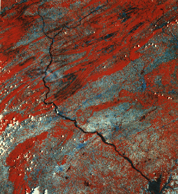
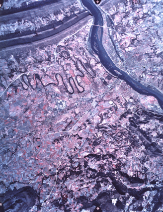
At a still larger scale, we next see a false color IR image of the Susquehanna Water Gap passing through Blue Mountain just north of Highway 81 (bottom of the picture) that, to the east, runs along the north side of Harrisburg.
Color IR Photo (1:8000)
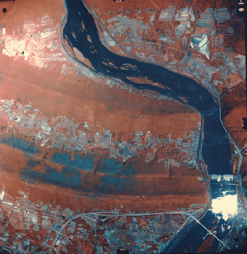
Much the same area is part of a small scale (large area coverage with reduced detail) aerial photo obtained from an RB-57 NASA aircraft flown at an altitude near 15200 meters (50000 ft) (see whether you can locate the large scale photo within it; use a magnifying glass if need be to pinpoint the small lake) on February 5, 1974. On this date, the color IR photo shows limited red tones found mainly in fields in which winter wheat is growing. The image is 25.2 km (15.7 miles) on a side (637 square km; 246 square miles).
Approximately the same area has been enlarged as a subset from a Landsat 1 MSS image obtained on October 11, 1973.
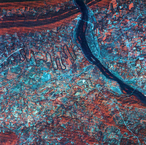
We leave it as an exercise for you to look for larger features present in both the high altitude aerial photo and the Landsat subset. Obviously, many details are lost in the latter but most of the major features present in the photo can be detected and identified in Landsat.
Two internal characteristics establish the pictorial content of an aerial photo (as well as space images): tones and tonal variations (as grays or colors) and patterns made by these. These, in turn, depend on the physical nature and distribution of the elements that make up a picture. We need, at this juncture, some basic insight into how a photo is made.
Code 935, Goddard Space Flight Center, NASA
Written by: Nicholas M. Short, Sr. email: nmshort@epix.net
and
Jon Robinson email: Jon.W.Robinson.1@gsfc.nasa.gov
Webmaster: Bill Dickinson Jr. email: rstwebmaster@gsti.com
Web Production: Christiane Robinson, Terri Ho and Nannette Fekete
Updated: 1999.03.15.