Many of the classes to be constituted for the Morro Bay scene are almost self-evident - ocean water, waves, beach, marsh, shadows. In practice, we could further sequester several such classes, as for example, distinguishing between ocean and bay waters, but their gross similarities in spectral properties would probably make separation difficult. Other classes that are likely variants of one another - such as slopes that either face the morning sun as Landsat flew over versus slopes facing away - might be warranted. Some classes are broad-based, being representative of two or more related surface materials that might be separable at high resolution but are inexactly expressed in the TM image: in this category we can include trees, forest, and heavily vegetated areas (golf course; farm fields).
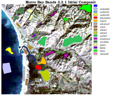
For the first attempt at a supervised classification, 13 discretional classes have been formalized. The outlines of their training sites are traced on the true color (bands 1,2,3) composite, as shown (their site colors are assigned here for display convenience and do not correspond to their class equivalent colors in the maps shown on the next page).
Note that Idrisi does not actually name them (they are numbered and given names [tied to the numbers]) during the stage when signatures are made. Several classes gain their data from more than one training site. Idrisi has a module, SIGCOMP, that plots the signature of each class. Here we show plots for clear seawater (light blue) and water with three different sediment densities (green, brown, blue-green) and surf waves (yellow-green).
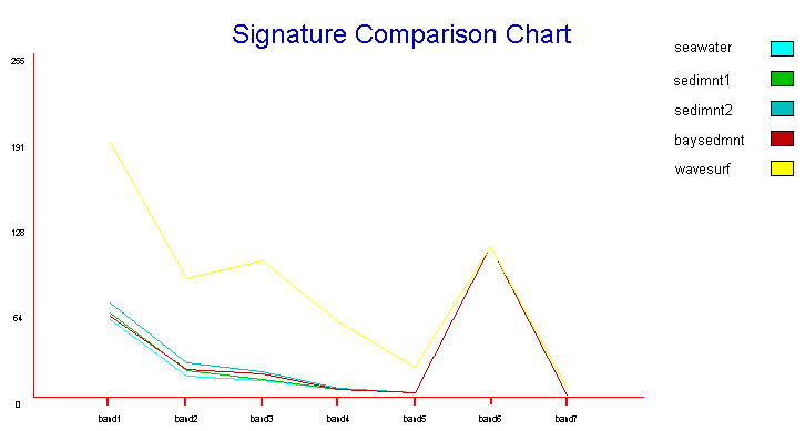
It also has a program that presents pixel information for each signature, recording the number of pixels contributing to the data, and the mean, maximum, minimum, and standard deviation of DN values for each signature. To help you get a deeper feel for the numerical inputs involved in these calculations, we have reproduced a simplified version of these data in the following table:
| BAND: | 1 | 2 | 3 | 4 | 5 | 6 (TH) | 7 | No. of Pixels |
|---|---|---|---|---|---|---|---|---|
| Class | ||||||||
| 1. Seawater | 57.4 | 16.0 | 12.0 | 5.6 | 3.4 | 112.0 | 1.5 | 2433 |
| 2. Sediments1 | 62.2 | 19.6 | 13.5 | 5.6 | 3.5 | 112.2 | 1.6 | 681 |
| 3. Sediments2 | 69.8 | 25.3 | 18.8 | 6.3 | 3.5 | 112.2 | 1.5 | 405 |
| 4. Bay Sediment | 59.6 | 20.2 | 16.9 | 6.0 | 3.4 | 111.9 | 1.6 | 598 |
| 5. Marsh | 61.6 | 22.8 | 27.2 | 42.0 | 37.3 | 117.9 | 14.9 | 861 |
| 6. Waves Surf | 189.5 | 88.0 | 100.9 | 56.3 | 22.3 | 111.9 | 6.4 | 1001 |
| 7. Sand | 90.6 | 41.8 | 54.2 | 43.9 | 86.3 | 121.3 | 52.8 | 812 |
| 8. Urban1 | 77.9 | 32.3 | 39.3 | 37.5 | 53.9 | 123.5 | 29.6 | 747 |
| 9. Urban2 | 68.0 | 27.0 | 32.7 | 36.3 | 52.9 | 125.7 | 27.7 | 2256 |
| 10. Sun Slope | 75.9 | 31.7 | 40.8 | 43.5 | 107.2 | 126.5 | 51.4 | 5476 |
| 11. Shade Slope | 51.8 | 15.6 | 13.8 | 15.6 | 14.0 | 109.8 | 5.6 | 976 |
| 12. Scrublands | 66.0 | 24.8 | 29.0 | 27.5 | 58.4 | 114.3 | 29.4 | 1085 |
| 13. Grass | 67.9 | 27.6 | 32.0 | 49.9 | 89.2 | 117.4 | 39.3 | 590 |
| 14. Fields | 59.9 | 22.7 | 22.6 | 54.5 | 46.6 | 115.8 | 18.3 | 259 |
| 15. Trees | 55.8 | 19.6 | 20.2 | 35.7 | 42.0 | 108.8 | 16.6 | 2048 |
| 16. Cleared | 73.7 | 30.5 | 39.2 | 37.1 | 88.4 | 127.9 | 45.2 | 309 |
Code 935, Goddard Space Flight Center, NASA
Written by: Nicholas M. Short, Sr. email: nmshort@epix.net
and
Jon Robinson email: Jon.W.Robinson.1@gsfc.nasa.gov
Webmaster: Bill Dickinson Jr. email: rstwebmaster@gsti.com
Web Production: Christiane Robinson, Terri Ho and Nannette Fekete
Updated: 1999.03.15.