Now, at last we approach the finale of this Tutorial section during which you will become familiar with three of the common methods for identifying features in and thereby classifying images. Both unsupervised and supervised methods will be demonstrated.
In an unsupervised classification, the objective is to group multiband spectral response patterns into clusters that are statistically separable. Thus, a small range of digital numbers (DNs) for, say 3 bands, can fix one cluster that is set apart from a specified range combination for another cluster (and so forth). Separation will depend on the parameters chosen to differentiate. This can be visualized with the aid of this diagram, taken from Sabins, Remote Sensing: Principles and Interpretation. 2nd Ed. for four classes: A = Agriculture; d= Desert; M = Mountains; W = Water.
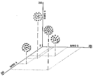
From F.F. Sabins, Jr., Remote Sensing: Principles and Interpretation. 2nd Ed., © 1987. Reproduced by permission of W.H. Freeman & Co., New York City.
These can be modified so that the total number of clusters can vary arbitrarily. When the separations are carried out on the computer, each pixel in an image will be assigned to one of the clusters as being most similar to it in DN combination values. Generally, in an area within an image, multiple pixels in the same cluster will correspond to some (initially unknown) ground feature or class so that patterns of gray levels will result in a new image depicting the spatial distribution of the clusters. These levels can then be assigned colors to produce a cluster "map". The trick then becomes one of trying to relate the different clusters to meaningful ground categories. This must be done by either being adequately familiar with the major classes expected in the scene under study or, where feasible, by visiting the scene itself - ground truthing - and visually correlating map patterns to their ground counterparts. Since the classes are not selected beforehand, this method is said to be unsupervised.
The Idrisi image processing program employs a simplified approach to unsupervised classification. Input data consist of the DN values of the registered pixels for the 3 bands used to make any of the color composites. Algorithms calculate the cluster values from these bands. The maximum number of clusters is automatically determined by the parameters selected in the processing. This typically has the effect of producing so many clusters that the resulting classified image becomes too cluttered and thus more difficult to interpret in terms of assigned classes. To improve the interpretability, the number of classes has been limited to 15 (reduction from an initial 28).
The first unsupervised classification operates on the color composite made from bands 2, 3, and 4. Examine the resulting image
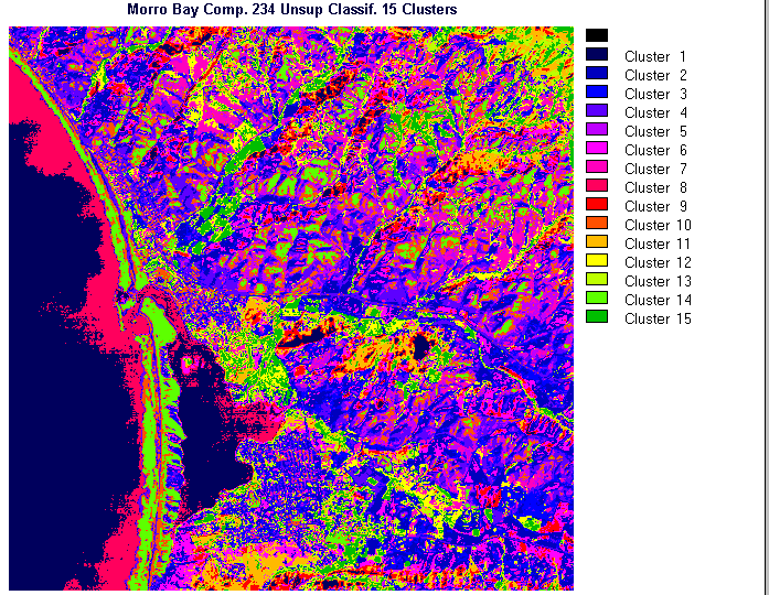
and try to make some sense of the color patterns as indicators of the ground classes you have learned about in the above paragraphs. A likely conclusion that you will reach: some of the patterns do well in singling out some of the features in some parts of the Morro Bay subscene. But, many individual areas represented by clusters do not appear to correlate that well with what you thought was there. Unfortunately, what is happening is a rather artificial subdivision of spectral responses from small segments of the surface, in some instances simply the effect of slight variations in surface orientation that changes the reflectances or perhaps the influence of what was termed "mixed pixels" in the Overview. When we try another composite,
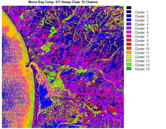
bands 4, 7, and 1, the new resulting classification has most of the same problems as encountered with the first composite. We are forced to conclude that unsupervised classification is too much of a generalization and that the clusters only roughly match some of the actual classes. Its value is mainly as a guide to the spectral content of a scene to aid in making a preliminary interpretation prior to conducting the much more powerful supervised classification procedures.
Code 935, Goddard Space Flight Center, NASA
Written by: Nicholas M. Short, Sr. email: nmshort@epix.net
and
Jon Robinson email: Jon.W.Robinson.1@gsfc.nasa.gov
Webmaster: Bill Dickinson Jr. email: rstwebmaster@gsti.com
Web Production: Christiane Robinson, Terri Ho and Nannette Fekete
Updated: 1999.03.15.